MAKE A MEME
View Large Image

| View Original: | VTALightRail.svg (1618x1657) | |||
| Download: | Original | Medium | Small | Thumb |
| Courtesy of: | commons.wikimedia.org | More Like This | ||
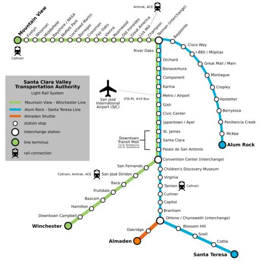
| Keywords: VTALightRail.svg Map of Santa Clara Valley Transportation Authority light rail system Created by Bayberrylane at en wikipedia using Inkscape version 0 43 June 16 2006 Modified by ChrisRuvolo cleaned up SVG made more legible removed unneeded whitespace removed traces of other rail lines added train and airport icons from File 20 airtransportation svg and File 25 railtransportation svg public domain from commons 2006-06-17 Bayberrylane wikipedia en Released into the public domain by the author Bayberrylane Original upload log en wikipedia Innotata CommonsHelper page en wikipedia VTALightRail svg 2007-01-05 19 03 ChrisRuvolo 1688×1688× 91222 bytes <nowiki>changed air and rail icons to public domain icons from commons Image 20 airtransportation svg Image 25 railtransportation_trans svg</nowiki> 2006-08-23 17 17 ChrisRuvolo 1688×1688× 95075 bytes <nowiki>update text positioning anchors</nowiki> 2006-08-23 17 10 ChrisRuvolo 1688×1688× 95080 bytes <nowiki>major cleanup of map</nowiki> 2006-06-17 03 11 Bayberrylane 2188×1875× 83682 bytes <nowiki> Created by User Bayberrylane me using Inkscape version 0 43 June 16 2006 Map of Santa Clara Valley Transportation Authority light rail system as requested by other editors </nowiki> 2006-06-17 02 56 Bayberrylane 2188×1875× 94918 bytes <nowiki>Created by User Bayberrylane me using Inkscape version 0 43 June 16 2006 Map of Santa Clara Valley Transportation Authority light rail system as requested by other editors </nowiki> 2006-06-17 02 50 Bayberrylane 2188×1875× 94918 bytes <nowiki>Created by User Bayberrylane me using Inkscape version 0 43 June 16 2006 Map of Santa Clara Valley Transportation Authority light rail system as requested by other editors </nowiki> Santa Clara VTA Light Rail maps | ||||