MAKE A MEME
View Large Image
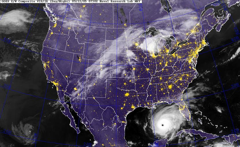
| View Original: | US_Navy_050922-N-0000X-001_GOES-12_Satellite_infrared_image_provided_by_the_U.S._Naval_Research_Laboratory,_Monterey,_Calif.,_showing_the_status_of_Hurricane_Rita_at_3-30_am_EST.jpg (1300x800) | |||
| Download: | Original | Medium | Small | Thumb |
| Courtesy of: | commons.wikimedia.org | More Like This | ||
| Keywords: US Navy 050922-N-0000X-001 GOES-12 Satellite infrared image provided by the U.S. Naval Research Laboratory, Monterey, Calif., showing the status of Hurricane Rita at 3-30 am EST.jpg en Gulf of Mexico Sept 22 2005 GOES-12 Satellite infrared image provided by the U S Naval Research Laboratory Monterey Calif showing the status of Hurricane Rita at 3 30 am EST Rita currently 490 miles Southeast of Galveston Texas was upgraded to a Category 5 storm late Wednesday with 170 mph winds sparking an order for mandatory evacuations in New Orleans and Galveston Texas The Military Sealift Command MSC hospital ship USNS Comfort T-AH 20 and other ships involved in Hurricane Katrina relief operations have been ordered to sortie in advance of Rita s arrival U S Navy photo RELEASED 2005-09-22 050922-N-0000X-001 Navy http //www navy mil/view_image asp id 28458 U S Navy photo PD-USGov-Military-Navy Hurricane Rita GOES 12 pictures Satellite pictures of North America | ||||