MAKE A MEME
View Large Image

| View Original: | The_Quarterly_journal_of_the_Geological_Society_of_London_(12511892755).jpg (3200x1869) | |||
| Download: | Original | Medium | Small | Thumb |
| Courtesy of: | commons.wikimedia.org | More Like This | ||
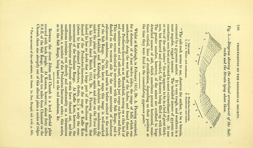
| Keywords: The Quarterly journal of the Geological Society of London (12511892755).jpg 198 <br> PROCEEDINGS OF THE GEOLOGICAL SOCIETY <br> Fig 3 Diagram showing the anticlinal arrangement of the Salt- <br> rocks and the Strata lying above them <br> 1 Salt-marl <br> 2 3 4 Shales and sandstones <br> 5 Productus-limestone <br> 6 Sandstones and shales <br> The salt-rock seems to me observes the author to be a breccia <br> cemented by a gypseous matter It is very tough and weathers in a <br> most angular rugged manner The included masses of gypsum are <br> sometimes seen bent and twisted in a most extraordinary way At one <br> or two of the salt-mines the salt appears to be in a bed of great thick- <br> ness but fissured and cracked the fissures being filled up with marl <br> The greater number however of the mines are confined to huge <br> detached masses of salt which sometimes present horizontal some- <br> times vertical lines of stratification depending on their position at <br> the time they were fixed in the consolidating gypseous paste <br> Whilst at Kalabagh in February 1851 Dr A Fleming examined <br> for a distance of at least twelve miles the range of hills which run <br> southwardly along the west bank of the Indus and found there the <br> same Productus-limestone as at Moosakhail resting on a thin bed of <br> red sandstone and red salt-marl which just crops out here and there <br> This range seems identical in structure with the Salt Range and is <br> flanked on the western side by the same succession of incoherent <br> calcareous sandstone clays and marls as before noticed to the north <br> of the Salt Range In the latest maps this range is well-marked <br> between Esakhail and Kalabagh and doubtless the sandstones dip <br> under the plain of Bunnoo to rise again and abut on the Teree hills <br> In his letter dated March 1852 Dr A Fleming observes that <br> indeed he has no doubt that a large part of the Sooliman Range is <br> formed of the Productus-limestone as the range at Kaffir Kote <br> where he has obtained Pi'oductus Orthis c is only the com- <br> mencement of the Sooliman Range At Kaffir Kote however the <br> nummulite limestone and Jurassic strata have thinned out and the <br> ossiferous tertiaries rest directly and conformably on a bituminous <br> sandstone a member of the Productus-limestone series ; this series <br> as in the Salt Range being based on the red sandstone c <br> Between the rivers Jelum and Chenab is a level alluvial plain <br> covered with bush jungle At Korana however about forty miles <br> S S E of the Salt Range and about ten miles from Chuniout on the <br> Chenab there rise abruptly out of this alluvial plain a series of ridges <br> For an account of the salt-mines see Journ As Soc Bengal vol xviii p 665 34983311 108767 51125 Page 198 Text v 9 http //www biodiversitylibrary org/page/34983311 1853 Geological Society of London NameFound Korana NameConfirmed Korana EOLID 4217064 NameBankID 4211421 NameFound Orthis NameConfirmed Orthis EOLID 4333134 NameBankID 4270859 NameFound Shales Biodiversity Heritage Library The Quarterly journal of the Geological Society of London v 9 1853 Geology Periodicals Smithsonian Libraries bhl page 34983311 dc identifier http //biodiversitylibrary org/page/34983311 smithsonian libraries Information field Flickr posted date ISOdate 2014-02-14 Check categories 2015 August 26 CC-BY-2 0 BioDivLibrary https //flickr com/photos/61021753 N02/12511892755 2015-08-27 09 58 24 cc-by-2 0 PD-old-70-1923 The Quarterly journal of the Geological Society of London 1853 Photos uploaded from Flickr by FĂŚ using a script | ||||