MAKE A MEME
View Large Image

| View Original: | The_Quarterly_journal_of_the_Geological_Society_of_London_(12684514343).jpg (1773x3200) | |||
| Download: | Original | Medium | Small | Thumb |
| Courtesy of: | commons.wikimedia.org | More Like This | ||
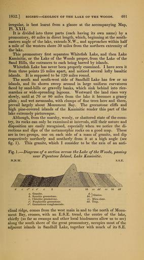
| Keywords: The Quarterly journal of the Geological Society of London (12684514343).jpg 1852 <br> BIGSBY GEOLOGY OF THE LAKE OF THE WOODS <br> 401 <br> irregular is best learnt from a glance at the accompanying Map <br> PI XXII <br> It is divided into three parts each having its own name by a <br> promontory 40 miles in direct length which beginning at the south- <br> eastern angle of the lake extends N W and approaches vsdthin half <br> a mile of the western shore 30 miles from the northern extremity of <br> the lake <br> This promontory first separates Whitefish Lake and then Lake <br> Kaminitic or the Lake of the Woods proper from the Lake of the <br> Sand Hills the entrances to each being barred by islands <br> Whitefish Lake has never been properly examined I have seen it <br> from three points 25 miles apart and noticed several lofty basaltic <br> islands It is supposed to be 120 miles round <br> The south and south-west side of Sandhill Lake has few or no <br> islands and its shores sweep around in large uniform curvatures <br> faced by sand-hills or gravelly banks which sink behind into rice- <br> marshes or wide-spreading lagoons Westward the land rises very <br> slowly until at 70 or 80 miles from the lake it becomes a grassy <br> plain ; and wet savannahs with clumps of fine trees here and there <br> prevail largely about Monument Bay The greenstone clifPs and <br> high pine-covered islands of the Kaminitic render this part of the <br> lake extremely picturesque <br> Although from the marshy woody or shattered state of the coun- <br> try its rocks can only be examined at intervals still their nature and <br> disposition are easily recognised especially when we notice the di- <br> rections and dips of the metamorphic rocks on a good map These <br> are in two groups one on each side of a mass of granite and dip <br> respectively northerly and southerly from it at a high angle see <br> fig 1 This granite which I consider to be the axis of an anti- <br> Fig 1 ” Diagram of a secfAon across the Lake of the Woods passing <br> near Pipestone Island Lake Kaminitic <br> N N W S S E <br> a Granite <br> b Syenitic greenstone <br> c Chloritic greenstone <br> c' Porphyritic greenstone <br> c Greenstone conglomerate <br> clinal ridge comes from the west main in and to the north of Monu- <br> ment Bay crosses with an E S E trend the centre of the lake <br> chiefly so far as swamps and other local hindrances allow us to see <br> along the south shore of the great promontory occupies most of the <br> adjacent islands in Sandhill Lake together with much of its S E 35461475 109911 51125 Page 401 Text v 8 http //www biodiversitylibrary org/page/35461475 1852 Geological Society of London Biodiversity Heritage Library The Quarterly journal of the Geological Society of London v 8 1852 Geology Periodicals Smithsonian Libraries bhl page 35461475 dc identifier http //biodiversitylibrary org/page/35461475 smithsonian libraries Information field Flickr posted date ISOdate 2014-02-21 Check categories 2015 August 26 CC-BY-2 0 BioDivLibrary https //flickr com/photos/61021753 N02/12684514343 2015-08-26 20 55 10 cc-by-2 0 PD-old-70-1923 The Quarterly journal of the Geological Society of London 1852 Photos uploaded from Flickr by Fæ using a script | ||||