MAKE A MEME
View Large Image

| View Original: | The_Quarterly_journal_of_the_Geological_Society_of_London_(12736009735).jpg (1866x3200) | |||
| Download: | Original | Medium | Small | Thumb |
| Courtesy of: | commons.wikimedia.org | More Like This | ||
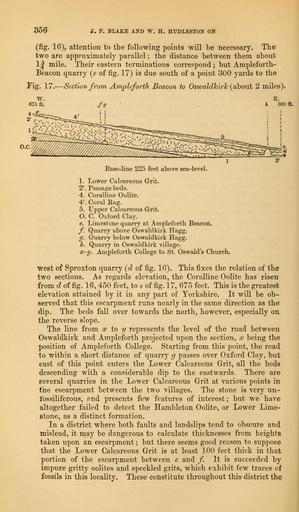
| Keywords: The Quarterly journal of the Geological Society of London (12736009735).jpg 356 <br> J F BLAKE AND W H H1JDLEST0N ON <br> fig 16 attention to the following points will be necessary The <br> two are approximately parallel ; the distance between them about <br> 1 J mile Their eastern terminations correspond ; but Ampleforth- <br> Beacon quarry e of fig 17 is due south of a point 300 yards to the <br> Fig 17 ” Section from Ampleforth Beacon to Oswaldkirlc about 2 miles <br> w <br> 675 ft <br> ac v;vvvx ; <br> Base-line 225 feet above sea-level <br> 1 Lower Calcareous Grit <br> 2' Passage beds <br> 4 Coralline Oolite <br> 4\ Coral Rag <br> 5 Upper Calcareous Grit <br> O C Oxford Clay <br> e Limestone quarry at Ampleforth Beacon <br> f Quarry above Oswaldkirk Hagg <br> g Quarry below Oswaldkirk Hagg <br> h Quarry in Oswaldkirk village <br> x-y Ampleforth College to St Oswald's Church <br> West of Sproxton quarry cl of fig 16 This fixes the relation of the <br> two sections As regards elevation the Coralline Oolite has risen <br> from d of fig 16 450 feet to e of fig 17 675 feet This is the greatest <br> elevation attained by it in any part of Yorkshire It will be ob- <br> served that this escarpment runs nearly in the same direction as the <br> dip The beds fall over towards the north however especially on <br> the reverse slope <br> The line from x to y represents the level of the road between <br> Oswaldkirk and Ampleforth projected upon the section x being the <br> position of Ampleforth College Starting from this point the road <br> to within a short distance of quarry g passes over Oxford Clay but <br> east of this point enters the Lower Calcareous Grit all the beds <br> descending with a considerable dip to the eastwards There are <br> several quarries in the Lower Calcareous Grit at various points in <br> the escarpment between the two villages The stone is very un- <br> tbssiliferous and presents few features of interest; but we have <br> altogether failed to detect the Hambleton Oolite or Lower Lime- <br> stone as a distinct formation <br> In a district where both faults and landslips tend to obscure and <br> mislead it may be dangerous to calculate thicknesses from heights <br> taken upon an escarpment ; but there seems good reason to suppose <br> that the Lower Calcareous Grit is at least 100 feet thick in that <br> portion of the escarpment between e and / It is succeeded by <br> impure gritty oolites and speckled grits which exhibit few traces of <br> fossils in this locality These constitute throughout this district the 35818485 110705 51125 Page 356 Text 33 http //www biodiversitylibrary org/page/35818485 1877 Geological Society of London Biodiversity Heritage Library The Quarterly journal of the Geological Society of London v 33 1877 Geology Periodicals Smithsonian Libraries bhl page 35818485 dc identifier http //biodiversitylibrary org/page/35818485 smithsonian libraries Information field Flickr posted date ISOdate 2014-02-24 Check categories 2015 August 26 CC-BY-2 0 BioDivLibrary https //flickr com/photos/61021753 N02/12736009735 2015-08-26 20 00 49 cc-by-2 0 PD-old-70-1923 The Quarterly journal of the Geological Society of London 1877 Photos uploaded from Flickr by Fæ using a script | ||||