MAKE A MEME
View Large Image

| View Original: | The_Quarterly_journal_of_the_Geological_Society_of_London_(12826739014).jpg (1179x2069) | |||
| Download: | Original | Medium | Small | Thumb |
| Courtesy of: | commons.wikimedia.org | More Like This | ||
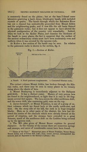
| Keywords: The Quarterly journal of the Geological Society of London (12826739014).jpg 1857 <br> SMYTH EXTINCT VOLCANOS OF VICTORIA <br> 229 <br> is commonly found on the plains ; but at the base I found some <br> labourers quarrying a hard dense bluish-grey basalt with included <br> crystals of quartz The basalt through which the Saltwater River <br> has cut a channel has undoubtedly proceeded from Mount Aitkin <br> and the neighbouring peaks and it now fills the old basin formed <br> in the palaeozoic rocks ; but it does not appear to have altered the <br> physical configuration of the country very remarkably Indeed <br> when we look at the Keilor Plains and examine the thickness of <br> the basalt in many places the fact is apparent that the surface of <br> the ancient sedimentary strata must have been moderately even and <br> uniform when it was covered by the igneous rock <br> At Keilor a fine section of the basalt may be seen Its relation <br> to the palaeozoic rocks is shown in the section fig 2 <br> Fig 2 ” Section at Keilor <br> 1 i ' i i ˘ ' i i <br> a Basalt b Hard quartzose conglomerate c Contorted Silurian rocks <br> The extinct volcano Mount Aitkin has broken through the Silu- <br> rian rocks and these may be seen in many places in its vicinity <br> rising above the sheets of lava <br> 3 Mount Boninyong is immediately adjacent to the Ballaarat <br> gold-fields It has a distinct crater Masses of very porous lava <br> are found in the neighbourhood so light that it is easy to lift frag- <br> ments several feet square The lava covers the older auriferous drift; <br> and the newer drift also containing gold rests on the top <br> 4 Lame-bar amul or Mount Franklyn is one of a group of ex- <br> tinct volcanos which are found both to the north south-east and <br> west On the steep side of the hill the rock is in huge irregular <br> blocks Here as in other parts of the district the lava has fol- <br> lowed the course of the channels which were already formed at the <br> period of eruption and the streams have extended to a great <br> distance much of the auriferous drift on the Loddon being covered <br> up by the igneous rock <br> 5 The MS plan given of Mount Rouse explains its general <br> character In the vicinity of the mount there are numerous springs <br> and swamps and caves of considerable extent have been found <br> Home of the Emu Manuscript plans of Mount Franklyn Mount Rouse <br> Mount Leura and of Tower Hill Lake from recent surveys accompanied this <br> memoir and are deposited in the Society's Library ” Ed 36214197 111684 51125 Page 229 Text v 14 http //www biodiversitylibrary org/page/36214197 1858 Geological Society of London Biodiversity Heritage Library The Quarterly journal of the Geological Society of London v 14 1858 Geology Periodicals Smithsonian Libraries bhl page 36214197 dc identifier http //biodiversitylibrary org/page/36214197 smithsonian libraries Information field Flickr posted date ISOdate 2014-02-28 Check categories 2015 August 26 CC-BY-2 0 BioDivLibrary https //flickr com/photos/61021753 N02/12826739014 2015-08-26 17 54 03 cc-by-2 0 PD-old-70-1923 The Quarterly journal of the Geological Society of London 1858 Photos uploaded from Flickr by Fæ using a script | ||||