MAKE A MEME
View Large Image

| View Original: | Swine flu outbreak in UK 28-02-2009.svg (675x1180) | |||
| Download: | Original | Medium | Small | Thumb |
| Courtesy of: | commons.wikimedia.org | More Like This | ||
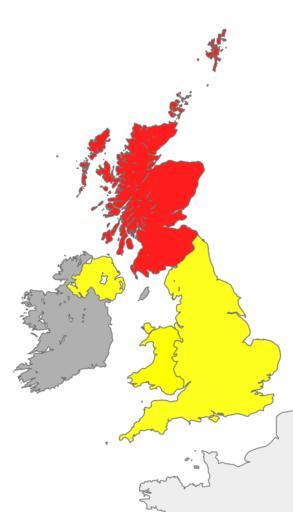
| Keywords: Swine flu outbreak in UK 28-02-2009.svg English A map to show swine flu in the UK as of 28 April 2009 Red confirmed case s Yellow Suspected case s Grey None reported Recolouring of svg by User Cnbrb File British Isles United Kingdom svg British_Isles_United_Kingdom svg 2009-04-28 16 40 UTC British_Isles_United_Kingdom svg Cnbrb derivative work Spaully <span class signature-talk >talk</span> Cnbrb 675x1180 310388 Bytes <nowiki> Summary map showing the territory of the United Kingdom in the context of the islands of Great Britain and Ireland self-made 2007-21-09 Cnbrb Catego</nowiki> Uploaded with derivativeFX checked Maps of the British Isles Maps of the islands of the North Atlantic Maps of the United Kingdom SVG maps of the United Kingdom 2009 swine flu outbreak in the United Kingdom 2009 swine flu outbreak maps Disease incidence maps of the United Kingdom | ||||