MAKE A MEME
View Large Image

| View Original: | St. Giles and Parliament House c.1647.JPG (1913x2472) | |||
| Download: | Original | Medium | Small | Thumb |
| Courtesy of: | commons.wikimedia.org | More Like This | ||
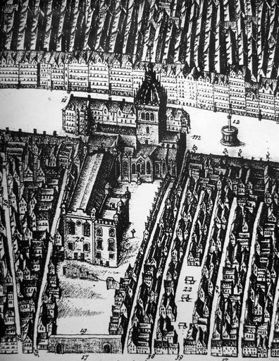
| Keywords: St. Giles and Parliament House c.1647.JPG en St Giles Kirk and Parliament House from James Gordon of Rothiemay's map of Edinburgh 1647 The building beyond St Giles is the row of open-fronted shops called the Luckenbooths The town's tolbooth occupied the left end of the row 2012-02-28 James Gordon of Rothiemay's map of Edinburgh 1647 James Gordon of Rothiemay Custom license marker 2012 02 28 PD-old ImageNote 1 425 1038 482 791 1913 2472 2 The Parliament House ImageNoteEnd 1 ImageNote 2 903 482 293 737 1913 2472 2 St Giles Kirk ImageNoteEnd 2 ImageNote 3 408 639 219 288 1913 2472 2 The Tolbooth ImageNoteEnd 3 ImageNote 4 1480 766 210 255 1913 2472 2 The High Cross ImageNoteEnd 4 ImageNote 7 820 2418 412 49 1913 2472 2 The Cowgate ImageNoteEnd 7 ImageNote 8 37 705 301 103 1913 2472 2 The High Street ImageNoteEnd 8 ImageNote 9 1179 1805 198 482 1913 2472 2 The Fish Market ImageNoteEnd 9 ImageNote 10 379 1903 383 379 1913 2472 2 The Meal Market ImageNoteEnd 10 ImageNote 11 631 643 276 243 1913 2472 2 Luckenbooths ImageNoteEnd 11 ImageNote 12 4 4 1905 379 1913 2472 2 'Lands' tenements on the north side of the High Street ImageNoteEnd 12 Historic parliament of the Kingdom of Scotland St Giles' Cathedral James_Gordon_of_Rothiemay | ||||