MAKE A MEME
View Large Image

| View Original: | Serbia ethnic 6 8 century-sr.png (638x1146) | |||
| Download: | Original | Medium | Small | Thumb |
| Courtesy of: | commons.wikimedia.org | More Like This | ||
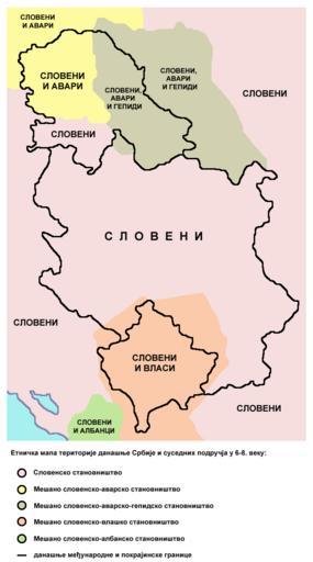
| Keywords: Serbia ethnic 6 8 century-sr.png en Ethnic map of the territory of present-day Serbia and neighbouring areas in the 6th-8th century according to the historical atlas for schools published in Belgrade in 1970 –ï—Ç–Ω–∏—á–∫–∞ –º–∞–ø–∞ —Ç–µ— –∏—Ç–æ— –∏—ò–µ –¥–∞–Ω–∞—à—ö–µ –°— –±–∏—ò–µ –∏ –æ–∫–æ–ª–Ω–∏—Ö –ø–æ–¥— —É—á—ò–∞ —É 6-8 –≤–µ–∫—É –º–∞–ø–∞ —ò–µ —É— –∞—í–µ–Ω–∞ –ø— –µ–º–∞ –®–∫–æ–ª—Å–∫–æ–º –∏—Å—Ç–æ— –∏—ò—Å–∫–æ–º –∞—Ç–ª–∞—Å—É –æ–±—ò–∞–≤—ô–µ–Ω–æ–º —É –ë–µ–æ–≥— –∞–¥—É 1970 –≥–æ–¥–∏–Ω–µ own PANONIAN 2014 Cc-zero References Main reference Created according to the historical map from this history atlas ≈Ýkolski istorijski atlas Zavod za izdavanje ud≈æbenika SR Srbije Beograd 1970 Secondary references with similar maps The Times - Atlas Svjetske Povijesti Dopunjeno izdanje za Jugoslaviju Cankarjeva zalo≈æba Ljubljana 1986 - this is Yugoslav Serbo-Croatian edition of this original source The Times Atlas of World History Times Books Limited London 1984 in Yugoslav version from 1986 there is similar map on page number 298 Denis ≈Ýehiƒá - Demir ≈Ýehiƒá Istorijski atlas Sveta Beograd 2007 similar map is published on page number 29 The former Yugoslavia's diverse peoples a reference sourcebook By Matja≈æ Klemenƒçiƒç Mitja ≈Ωagar http //books google com/books id ORSMBFwjAKcC pg PA3 lpg PA5 vq maps output html a source with similar map published on page number 3 Here is an external link with similar map http //www camo ch/illiricum7 htm Historical maps of ethnic groups in Serbia Historical maps of ethnic groups in Vojvodina Historical maps of ethnic groups in Kosovo Historical maps of ethnic groups in the Balkans Maps of the South Slavs Maps of the Gepids Maps of Eurasian Avars Avar Khaganate Maps of the Vlachs Maps of the history of Serbia in the Early Middle Ages Maps of the history of Romania in the Middle Ages Maps in Serbian | ||||