MAKE A MEME
View Large Image

| View Original: | Scotland_from_the_Matthew_Paris_map,_c.1250.jpg (522x399) | |||
| Download: | Original | Medium | Small | Thumb |
| Courtesy of: | commons.wikimedia.org | More Like This | ||
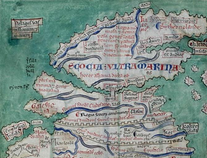
| Keywords: Scotland from the Matthew Paris map, c.1250.jpg page at Commons 2011-08-30 British Library Creator Matthew Paris PD-old-100 ImageNote 2 255 208 55 49 522 399 2 Stirling Bridge ImageNoteEnd 2 reads Wall separating the Scots and Picts of old ImageNoteEnd 3 ImageNote 6 69 250 75 37 522 399 2 Galloway orientated east-west rather than north-south ImageNoteEnd 6 ImageNote 7 79 300 32 18 522 399 2 Isle of Man ImageNoteEnd 7 ImageNote 8 3 306 65 42 522 399 2 Anglesay ImageNoteEnd 8 ImageNote 10 477 102 44 37 522 399 2 Orkney Islands shown off the east coast of Scotland rather than the north coast ImageNoteEnd 10 ImageNote 11 375 252 35 28 522 399 2 Edinburgh ImageNoteEnd 11 ImageNote 12 20 359 49 29 522 399 2 Snowdon ImageNoteEnd 12 ImageNote 13 165 130 55 19 522 399 2 Dumbarton ImageNoteEnd 13 ImageNote 14 411 86 43 16 522 399 2 Dundee ImageNoteEnd 14 ImageNote 16 410 122 57 23 522 399 2 St Andrews ImageNoteEnd 16 ImageNote 17 320 196 49 22 522 399 2 Dunfermline ImageNoteEnd 17 ImageNote 18 215 109 45 20 522 399 2 Dunkeld ImageNoteEnd 18 states A country marshy and impassable fit for cattle and shepherds ImageNoteEnd 19 ImageNote 20 185 268 65 18 522 399 2 River Clyde ImageNoteEnd 20 ImageNote 21 322 272 43 18 522 399 2 Glasgow located on the River Clyde but too far eastwards ImageNoteEnd 21 ImageNote 22 399 295 44 18 522 399 2 Berwick ImageNoteEnd 22 ImageNote 23 315 230 32 24 522 399 2 Queensferry ImageNoteEnd 23 ImageNote 24 135 346 35 25 522 399 2 Carlisle ImageNoteEnd 24 states A maritime district and a race of mountain people ImageNoteEnd 25 ImageNote 26 268 76 61 68 522 399 2 A mountainous and wooded region producing a people rude and pastoral by reason of marshes and fens ImageNoteEnd 26 ImageNote 27 62 145 31 48 522 399 2 Island of Columkille i e Columba hence Iona ImageNoteEnd 27 ImageNote 28 22 212 55 19 522 399 2 Island of Tyree ImageNoteEnd 28 ImageNote 29 28 47 73 49 522 399 2 A boundless and trackless sea ImageNoteEnd 29 ImageNote 30 349 4 34 21 522 399 2 Isle of May positioned off the wrong coast The island is actually located off the east coast at the mouth of the Firth of Forth ImageNoteEnd 30 ImageNote 32 430 44 70 15 522 399 2 Arbroath positioned on the wrong coast ImageNoteEnd 32 ImageNote 33 379 42 41 15 522 399 2 Aberdeen positioned on the wrong coast ImageNoteEnd 33 ImageNote 34 352 41 25 43 522 399 2 Caithness ImageNoteEnd 34 ImageNote 35 405 62 105 15 522 399 2 Sutherland ImageNoteEnd 35 ImageNote 36 350 97 55 19 522 399 2 An arm of the sea presumably the Moray Firth ImageNoteEnd 36 ImageNote 37 79 326 40 24 522 399 2 North Wales ImageNoteEnd 37 ImageNote 39 173 256 102 13 522 399 2 River making Clydesdale ImageNoteEnd 39 ImageNote 40 356 227 35 24 522 399 2 Earlsferry meaning the earl's ferry at North Berwick not to be confused with Earlsferry on the Fife coast opposite The ferry connected these two locations to assist pilgrims from the south journeying to St Andrews ImageNoteEnd 40 ImageNote 41 376 282 46 12 522 399 2 Tweeddale ImageNoteEnd 41 reads Wall separating the Angles and Picts of old ImageNoteEnd 42 ImageNote 43 275 327 32 16 522 399 2 Melrose ImageNoteEnd 43 ImageNote 44 310 324 23 20 522 399 2 Roxburgh ImageNoteEnd 44 ImageNote 45 419 369 65 15 522 399 2 Cheviot Hills ImageNoteEnd 45 ImageNote 46 465 305 35 32 522 399 2 Lindisfarne ImageNoteEnd 46 ImageNote 47 169 154 284 43 522 399 2 SCOTLAND BEYOND THE SEA This is also called Albany ImageNoteEnd 47 Uploaded with UploadWizard Matthew Paris Abbreuiatio chronicorum AD 1000 “1255 13th C - BL Cotton MS Claudius D VI 012vd Maps by Matthew Paris Britain D1 1250s maps Old maps of Scotland 1250 History of Scotland | ||||