MAKE A MEME
View Large Image

| View Original: | Nevado_del_Ruiz_hazard_map,_from_Wright_and_Pierson_ESP.png (675x450) | |||
| Download: | Original | Medium | Small | Thumb |
| Courtesy of: | commons.wikimedia.org | More Like This | ||
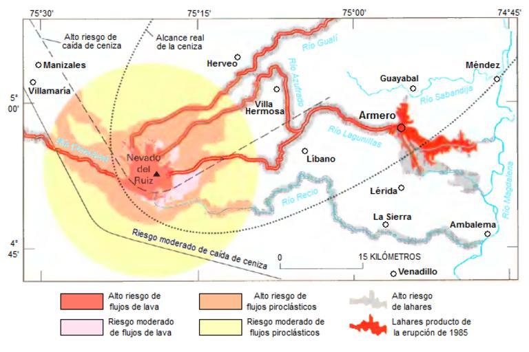
| Keywords: Nevado del Ruiz hazard map, from Wright and Pierson ESP.png en Original caption Map showing hazards expected from an eruption of Nevado del Ruiz Colombia Such a map was prepared by INGEOMINAS Colombian Institute of Geology and Mines and circulated 1 month prior to the November 13 1985 eruption of Nevado del Ruiz Map shows danger from mudflows in the valley occupied by the town of Armero Colombia as well as areas affected by the hazards that resulted from this eruption Circle denotes 20-kilometer limit es Leyenda original Mapa que muestra los riesgos esperados producto de una erupción del Nevado del Ruiz Colombia El mapa fue preparado por INGEOMINAS Instituto Colombiano de Geología y Minería y circuló un mes antes de la erupción del Nevado del Ruiz ocurrida el 13 de noviembre de 1985 El mapa muestra el peligro producto de lahares en el valle ocupado por el pueblo de Armero así como las áreas afectadas por los riesgos producto de la erupción 2012-04-24 Page 21 in Wright Thomas L and Pierson Thomas C 1992 Living with volcanoes DJVU format USGS Circular 1073 Bibliographic information and link to DJVU reader are online here Nevado_del_Ruiz_hazard_map _from_Wright_and_Pierson png Nevado_del_Ruiz_hazard_map _from_Wright_and_Pierson png Wright Thomas L and Pierson Thomas C Derivative work Elviper <span class signature-talk >talk</span> 02 21 25 April 2012 UTC Original image 100px Nevado del Ruiz hazard map from Wright and Pierson png PD-USGov Uploaded with UploadWizard Armero tragedy Lahars | ||||