MAKE A MEME
View Large Image
| View Original: | Netherlands,_Rimburg,_Map_of_1866.PNG (1377x1214) | |||
| Download: | Original | Medium | Small | Thumb |
| Courtesy of: | commons.wikimedia.org | More Like This | ||
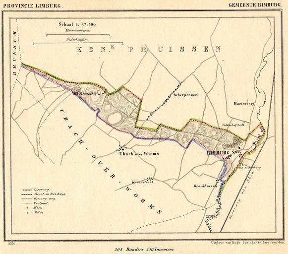
| Keywords: Netherlands, Rimburg, Map of 1866.PNG nl Kaart uit 1866 van de voormalige gemeente Rimburg prov Limburg Rimburg ging in 1886 op in de gemeente Ubach-over-Worms Sinds 1982 vormt Ubach-over-Worms samen met de gemeenten Nieuwenhagen en Schaesberg de gemeente Landgraaf Rimburg ligt dus momenteel in de gemeente Landgraaf en Map from 1866 of the former municipality of Rimburg province of Limburg Netherlands In 1886 Rimburg was absorbed by the municipality of Ubach-over-Worms In 1982 the municipalities Ubach-over-Worms Nieuwenhagen and Schaesberg joined to form the municipality of Landgraaf Rimburg is therefore currently in Landgraaf Gemeente-atlas van Nederland naar officieele bronnen bewerkt J Kuyper 1866 Published as part of a series of provincial atlases of the Netherlands between 1865-1870 This image is in the public domain The author J Kuyper died in 1908 In the Netherlands copyright expires 70 years after the death of the author or 70 years after first publication in the case of anonymous or pseudonymous works or works published by a legal entity Het auteursrecht in Nederland vervalt 70 jaar na de dood van de auteur of 70 jaar na de eerste openbaarmaking van het werk indien het gaat om een anoniem of om een onder pseudoniem verschenen werk of werk van een rechtspersoon The church of Rimburg is located at 50 54 57 5 N 6 5 15 98 E region NL Rimburg Maps of Landgraaf 1866 in the Netherlands Gemeente Atlas van Nederland - Limburg PD-old | ||||