MAKE A MEME
View Large Image

| View Original: | Map of Truckee Lake and Alder Creek.png (1631x1197) | |||
| Download: | Original | Medium | Small | Thumb |
| Courtesy of: | commons.wikimedia.org | More Like This | ||
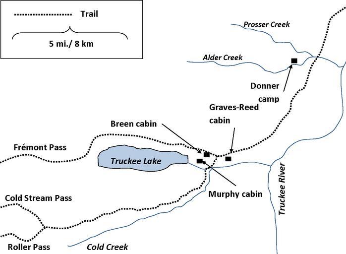
| Keywords: Map of Truckee Lake and Alder Creek.png en wikipedia 2013 July 23 Map showing the locations of the winter encampment at Truckee Lake where most of the Donner Party were trapped during the winter of 1846-1847 and its proximity to Alder Creek where the Donner families stayed Amalgamation of two sources Johnson Kristin ed 1996 Unfortunate Emigrants Narratives of the Donner Party Utah State University Press 1996 ISBN 0-87421-204-9 p 45 and Hardesty Donald 1997 The Archaeology of the Donner Party University of Nevada Press ISBN 0-87417-290-X p 6 2010 Moni3 public domain Map of Truckee Lake and Alder Creek svg Moni3 Original upload log en wikipedia Sfan00_IMG CommonsHelper en wikipedia Map_of_Truckee_Lake_and_Alder_Creek png 2010-03-19 00 42 Moni3 1631×1197× 37653 bytes <nowiki>Cropped </nowiki> 2010-03-18 20 44 Moni3 1825×1350× 41092 bytes <nowiki> Map showing the locations of the winter encampment at Truckee Lake where most of the Donner Party were trapped during the winter of 1846-1847 and its proximity to Alder Creek where the Donner families stayed Amalgama</nowiki> Uncategorized 2013 July 23 | ||||