MAKE A MEME
View Large Image

| View Original: | Map_of_Sweden_(1797).tif (1149x1024) | |||
| Download: | Original | Medium | Small | Thumb |
| Courtesy of: | commons.wikimedia.org | More Like This | ||
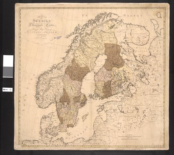
| Keywords: Map of Sweden (1797).tif ar ž¬žĖ┘ćž▒ ┘ćž░┘ć ž¦┘äž«ž▒┘ŖžĘž® ┘ģ┘ģ┘ä┘āž® ž¦┘äž│┘ł┘Ŗž» ┘ā┘ģž¦ ┘āž¦┘垬 ┘ü┘Ŗ ┘å┘枦┘Ŗž®ž¦┘ä┘éž▒┘å ž¦┘äž½ž¦┘ģ┘å ž╣ž┤ž▒ ┘ł┘éž» ž┤┘ģ┘䞬 ž¦┘ä┘ģ┘ģ┘ä┘āž® ┘ü┘Ŗ ž░┘ä┘ā ž¦┘ä┘ł┘鞬 ž¦┘äž│┘ł┘Ŗž» ž¦┘䞣ž¦┘ä┘Ŗž® ž©ž¦┘äžźžČž¦┘üž® žź┘ä┘ē ┘ü┘å┘ä┘åž»ž¦ ž¦┘䞬┘Ŗžī ┘ģž╣ ž░┘ä┘āžī ┘ü┘éž»ž¬┘枦 ž¦┘äž│┘ł┘Ŗž» ┘ä┘äžź┘ģž©ž▒ž¦žĘ┘łž▒┘Ŗž® ž¦┘äž▒┘łž│┘Ŗž® ┘ü┘Ŗ ž╣ž¦┘ģ ┘Ī┘©┘Ā┘® ┘łž¦┘äž«ž▒┘ŖžĘž® ┘ģ┘å ž╣┘ģ┘ä žĄ┘ģ┘ł┘Ŗ┘ä ž║┘łž│ž¬ž¦┘ü ┘Ī┘¦┘ż┘ż-┘Ī┘©┘ó┘Ā žī ž¦┘äž»ž©┘ä┘ł┘ģž│┘Ŗ ┘łž▒ž¼┘ä ž¦┘䞥┘垦ž╣ž® ž¦┘äž│┘ł┘Ŗž»┘Ŗ ž¦┘äž░┘Ŗ ┘ģž¦ž▒ž│ ž▒ž│┘ģ ž¦┘äž«ž▒ž¦ž”žĘ žŻ┘ŖžČž¦ ž»ž▒ž│ ┘ć┘Ŗž▒┘ģ┘Ŗ┘ä┘Ŗ┘å ž¦┘䞬ž╣ž»┘Ŗ┘å ┘ü┘Ŗ ž¼ž¦┘ģž╣ž® žŻž©ž│ž¦┘䞦 ┘éž©┘ä ž│┘üž▒┘ć žź┘ä┘ē ž¦┘ä┘ł┘䞦┘Ŗž¦ž¬ ž¦┘ä┘ģž¬žŁž»ž® ┘äž»ž▒ž¦ž│ž® ž¦┘䞬žĄ┘å┘Ŗž╣ ┘łž©┘Ŗ┘å┘ģž¦ ┘āž¦┘å ┘ü┘Ŗ žŻ┘ģž▒┘Ŗ┘āž¦ ž¦┘äž┤┘ģž¦┘ä┘Ŗž®žī ┘äž╣ž© ž»┘łž▒ž¦ žŻž│ž¦ž│┘Ŗž¦ ┘ü┘Ŗ žź┘鞦┘ģž® ž╣┘䞦┘鞦ž¬ ž»ž©┘ä┘ł┘ģž¦ž│┘Ŗž® ž©┘Ŗ┘å ž¦┘äž│┘ł┘Ŗž» ┘łž¦┘ä┘ł┘䞦┘Ŗž¦ž¬ ž¦┘ä┘ģž¬žŁž»ž® žŁžŻ┘ł┘ä ┘ć┘Ŗ┘ģ┘ä┘Ŗ┘å ž©ž╣ž» ž╣┘łž»ž¬┘ć žź┘ä┘ē ž©┘䞦ž»┘ć ž©ž»žĪ ž╣┘ģ┘ä ž¬ž¼ž¦ž▒┘Ŗ ┘ģž▒ž©žŁ ┘ü┘Ŗ ž¦┘䞬ž╣ž»┘Ŗ┘å ┘ü┘Ŗ ┘ģ┘åžĘ┘éž® ┘䞦ž©┘䞦┘åž» ž¦┘äž│┘ł┘Ŗž»┘Ŗž®žī ┘ł┘ä┘ā┘å ┘ģž½┘ä ┘ćž░┘ć ž¦┘äž╣┘ģ┘ä┘Ŗž¦ž¬ žŻžĄž©žŁž¬ ┘ģž▒ž©žŁž® ž©ž╣ž» ┘ł┘üž¦ž¬┘ć ┘ü┘éžĘžī ž╣┘åž»┘ģž¦ žŻ┘Å┘åž┤ž”ž¬ ž¦ž¬žĄ┘䞦ž¬ ž¦┘äž│┘ā┘ā ž¦┘䞣ž»┘Ŗž»┘Ŗž® ž©┘Ŗ┘å ┘䞦ž©┘䞦┘åž» ┘łž¼┘å┘łž© ž¦┘äž│┘ł┘Ŗž» en This map shows the Kingdom of Sweden as it appeared at the end of the 18th century At the time the kingdom included present-day Sweden as well as Finland which however was lost to the Russian Empire in 1809 The map is the work of Samuel Gustaf Hermelin 1744-1820 a Swedish industrialist and diplomat who also practiced cartography Hermelin studied mining at the University of Uppsala before traveling to the United States to study industrialization While in North America he was instrumental in establishing diplomatic relations between Sweden and the United States After his return home Hermelin tried to start a profitable mining business in Swedish Lapland but such operations only became profitable after Hermelin Ös death when rail connections were established between Lapland and southern Sweden es Este mapa muestra el reino de Suecia tal y como era a finales del siglo XVIII En esos momentos el reino inclu├Ła tanto la actual Suecia como Finlandia que sin embargo se perdi├│ a favor del Imperio Ruso en 1809 El mapa es obra de Samuel Gustaf Hermelin 1744-1820 un empresario y diplom├Ītico sueco que tambi├®n era aficionado a la cartograf├Ła Hermelin estudi├│ miner├Ła en la Universidad de Uppsala antes de viajar a los Estados Unidos para estudiar industrializaci├│n Mientras estaba en Am├®rica del Norte contribuy├│ de manera importante a establecer relaciones diplom├Īticas entre Suecia y los Estados Unidos Al volver a casa Hermelin intent├│ establecer un negocio minero rentable en la Laponia sueca pero el negocio s├│lo empez├│ a ser rentable tras su muerte cuando se establecieron l├Łneas de ferrocarril entre Laponia y la parte sur de Suecia ž│┘łž”ž» ž»ž▒ █▒█Ę█╣█Ę ┘ģ█ī┘䞦ž»█ī fr Cette carte montre le Royaume de Su├©de ├Ā la fin du 18├©me si├©cle ├ l'├®poque le royaume comprenait l'actuelle Su├©de la Finlande qui cependant a ├®t├® c├®d├®e ├Ā l'empire Russe en 1809 La carte est l'┼ōuvre de Samuel Gustaf Hermelin 1744-1820 un industriel et un diplomate su├®dois qui a aussi pratiqu├® la cartographie Hermelin a ├®tudi├® l'exploitation mini├©re ├Ā l'Universit├® d'Uppsala avant de voyager aux ├ētats-Unis pour ├®tudier l'industrialisation En Am├®rique du Nord il a contribu├® ├Ā l'├®tablissement des relations diplomatiques entre la Su├©de et les ├ētats-Unis Apr├©s son retour dans son pays natal Hermelin tent├ót de d├®marrer une entreprise rentable dans l'exploitation mini├©re en Laponie su├®doise mais ces activit├®s ne sont devenus rentables qu'apr├©s sa mort quand les liaisons ferroviaires ont ├®t├® ├®tablies entre la Laponie et le sud de la Su├©de pt Este mapa mostra o Reino da Su├®cia conforme era no final do s├®culo XVIII Na ├®poca o reino inclu├Ła a atual Su├®cia bem como a Finl├óndia que contudo foi tomada pelo Imp├®rio Russo em 1809 O mapa ├® obra de Samuel Gustaf Hermelin 1744-1820 um industrial e diplomata sueco que tamb├®m trabalhava com cartografia Hermelin estudou minera├¦├Żo na Universidade de Uppsala antes de viajar aos Estados Unidos para estudar industrializa├¦├Żo Durante sua estadia nos Estados Unidos ele exerceu papel fundamental no estabelecimento das rela├¦├Ąes diplom├Īticas entre a Su├®cia e os Estados Unidos Ap├│s seu regresso ├Ā terra natal Hermelin tentou iniciar um neg├│cio de mineira├¦├Żo rent├Īvel na Laponia sueca mas essas opera├¦├Ąes s├│ se tornaram rent├Īveis ap├│s sua morte quando foram estabelecidas liga├¦├Ąes ferrovi├Īrias entre a Laponia e o sul da Su├®cia ru ą ą░ čŹč鹊ą╣ ą║ą░č č鹥 ąĖąĘąŠą▒č ą░ąČąĄąĮąŠ ą║ąŠč ąŠą╗ąĄą▓čüčéą▓ąŠ ą©ą▓ąĄčåąĖąĖ ą▓ č鹊ą╝ ą▓ąĖą┤ąĄ ą║ą░ą║ ąŠąĮąŠ čüčāčēąĄčüčéą▓ąŠą▓ą░ą╗ąŠ ą▓ ą║ąŠąĮčåąĄXVIII ą▓ąĄą║ą░ ąÆ č鹊 ą▓č ąĄą╝čÅ ą▓ čüąŠčüčéą░ą▓ ą║ąŠč ąŠą╗ąĄą▓čüčéą▓ą░ ą▓čģąŠą┤ąĖą╗ą░ čüąŠą▓č ąĄą╝ąĄąĮąĮą░čÅ ą©ą▓ąĄčåąĖčÅ ą░ čéą░ą║ąČąĄ ążąĖąĮą╗čÅąĮą┤ąĖčÅ č鹥č č ąĖčéąŠč ąĖčÅ ą║ąŠčéąŠč ąŠą╣ ąŠą┤ąĮą░ą║ąŠ ą▓1809 ą│ąŠą┤čā ą▒čŗą╗ą░ ą┐ąĄč ąĄą┤ą░ąĮą░ ąĀąŠčüčüąĖą╣čüą║ąŠą╣ ąĖą╝ą┐ąĄč ąĖąĖ ąöą░ąĮąĮą░čÅ ą║ą░č čéą░ ą▒čŗą╗ą░ čüąŠčüčéą░ą▓ą╗ąĄąĮą░ ąĪą░ą╝čÄ菹╗ąĄą╝ ąōčāčüčéą░ą▓ąŠą╝ ąźąĄč ą╝ąĄą╗ąĖąĮąŠą╝ 1744-1820 ą│ą│ ö čłą▓ąĄą┤čüą║ąĖą╝ ą┐č ąŠą╝čŗčłą╗ąĄąĮąĮąĖą║ąŠą╝ ąĖ ą┤ąĖą┐ą╗ąŠą╝ą░č鹊ą╝ ą║ąŠč鹊č čŗą╣ čéą░ą║ąČąĄ ąĘą░ąĮąĖą╝ą░ą╗čüčÅ ą║ą░č č鹊ą│č ą░čäąĖąĄą╣ ą¤ąĄč ąĄą┤ č鹥ą╝ ą║ą░ą║ ąŠčéą┐č ą░ą▓ąĖčéčīčüčÅ ą▓ ąĪąŠąĄą┤ąĖąĮąĄąĮąĮčŗąĄ ą©čéą░čéčŗ ą┤ą╗čÅ ąĖąĘčāč湥ąĮąĖčÅ ąĖąĮą┤čāčüčéč ąĖą░ą╗ąĖąĘą░čåąĖąĖ ąźąĄč ą╝ąĄą╗ąĖąĮ ąĖąĘčāčćą░ą╗ ą│ąŠč ąĮąŠąĄ ą┤ąĄą╗ąŠ ą▓ ąŻą┐ą┐čüą░ą╗čīčüą║ąŠą╝ čāąĮąĖą▓ąĄč čüąĖč鹥č鹥 ąÆąŠ ą▓č ąĄą╝čÅ ąĄą│ąŠ ą┐č ąĄą▒čŗą▓ą░ąĮąĖčÅ ą▓ ąĪąĄą▓ąĄč ąĮąŠą╣ ąÉą╝ąĄč ąĖą║ąĄ ąŠąĮ ą▓ąĮąĄčü ąĘąĮą░čćąĖč鹥ą╗čīąĮčŗą╣ ą▓ą║ą╗ą░ą┤ ą▓ čāčüčéą░ąĮąŠą▓ą╗ąĄąĮąĖąĄ ą┤ąĖą┐ą╗ąŠą╝ą░čéąĖč湥čüą║ąĖčģ ąŠčéąĮąŠčłąĄąĮąĖą╣ ą╝ąĄąČą┤čā ą©ą▓ąĄčåąĖąĄą╣ ąĖ ąĪąŠąĄą┤ąĖąĮąĄąĮąĮčŗą╝ąĖ ą©čéą░čéą░ą╝ąĖ ą¤ąŠ ą▓ąŠąĘą▓č ą░čēąĄąĮąĖąĖ ąĮą░ č ąŠą┤ąĖąĮčā ąźąĄč ą╝ąĄą╗ąĖąĮ ą┐č ąĄą┤ą┐č ąĖąĮčÅą╗ ą┐ąŠą┐čŗčéą║čā ąŠč ą│ą░ąĮąĖąĘąŠą▓ą░čéčī ą┐č ąĖą▒čŗą╗čīąĮčŗą╣ ą│ąŠč ąĮąŠą┤ąŠą▒čŗą▓ą░čÄčēąĖą╣ ą▒ąĖąĘąĮąĄčü ą▓ čłą▓ąĄą┤čüą║ąŠą╣ ąøą░ą┐ą╗ą░ąĮą┤ąĖąĖ ąĮąŠ ąĄą│ąŠ ą┐č ąĄą┤ą┐č ąĖčÅčéąĖčÅ ąĮą░čćą░ą╗ąĖ ą┐č ąĖąĮąŠčüąĖčéčī ą┐č ąĖą▒čŗą╗čī ą╗ąĖčłčī ą┐ąŠčüą╗ąĄ ąĄą│ąŠ čüą╝ąĄč čéąĖ ą║ąŠą│ą┤ą░ ą╝ąĄąČą┤čā ąøą░ą┐ą╗ą░ąĮą┤ąĖąĄą╣ ąĖ čĹȹĮčŗą╝ąĖ č ąĄą│ąĖąŠąĮą░ą╝ąĖ ą©ą▓ąĄčåąĖąĖ ą▒čŗą╗ą░ ą┐č ąŠą╗ąŠąČąĄąĮą░ ąČąĄą╗ąĄąĘąĮą░čÅ ą┤ąŠč ąŠą│ą░ zh-hans Ķ┐ÖÕ╣ģÕ ░ÕøŠµÅÅĶ┐░õ║å 18 õĖ¢ń║¬µÖܵ ¤ńÜäńæ×ÕģĖńÄŗÕøĮŃ é õĖ¢ń║¬Ń é ÕĮōµŚČ’╝īĶ»źńÄŗÕøĮÕīģµŗ¼õ╗Ŗńæ×ÕģĖõĖÄĶŖ¼Õģ░’╝īńäČĶ īÕ © 1809 Õ╣┤ÕĘ▓õĖŹÕåŹÕ▒×õ║Äõ┐äńĮŚµ¢»ÕĖ ÕøĮŃ é Ķ┐ÖÕ╣ģÕ ░ÕøŠÕć║Ķć¬ÕĪ×ń╝¬Õ░ö┬ĘÕÅżµ¢»ÕĪöÕż½┬ĘĶĄ½Õ░öµóģµ×Ś’╝ł1744 - 1820 Õ╣┤’╝ē’╝īõĖ ÕÉŹń夵éēÕłČÕøŠńÜäńæ×ÕģĖõ╝üõĖÜÕ«ČõĖÄÕż¢õ║żÕ«śŃ é Õ ©ÕēŹÕŠ ńŠÄÕøĮÕŁ”õ╣ĀÕĘźõĖÜõ╣ŗÕēŹ’╝īĶĄ½Õ░öµóģµ×ŚÕ ©õ╣īµÖ«ĶÉ©µŗēÕż¦ÕŁ”µĮ Õ┐āÕŁ”õ╣Āń¤┐õĖÜŃ é Ķ║½ÕżäÕīŚńŠÄµŚČ’╝īõ╗¢µøŠõĖ Õ║”ÕĖ«ÕŖ®Õ╗║ń½ŗńæ×ÕģĖõĖÄńŠÄÕøĮńÜäÕż¢õ║żÕģ│ń│╗Ń é Õø×ÕøĮÕÉÄ’╝īĶĄ½Õ░öµóģµ×ŚÕ░ Ķ»ĢÕ ©ńæ×ÕģĖµŗēµÖ«Õģ░ń╗ÅĶÉźõĖ Õ«ČÕł®µČ”ķóćõĖ░ńÜäķććń¤┐õ╝üõĖÜ’╝īõĮåńø┤Ķć│õ╗¢ÕÄ╗õĖ¢ÕÉÄ’╝īõ╗¢ńÜäÕģ¼ÕÅĖµēŹÕ╝ Õ¦ŗńøłÕł®’╝īÕøĀõĖ║µŁżµŚČńÜäµŗēµÖ«Õģ░õĖÄńæ×ÕģĖÕŹŚµ¢╣Õ¤ÄÕĖéµēŹķ ÜķōüĶĘ»Ń é 1797 http //www wdl org/en/item/1225/ Creator Samuel Gustaf Hermelin 65 x 68 centimeters PD-old-100 Images from the World Digital Library Old maps of Sweden Maps in Swedish Old maps of Finland Old maps of Denmark Maps of the history of Latvia Old maps of Lithuania under Russian and German empires Old maps of Norway 18th-century maps of Estonia Old maps of the Russian Empire 1797 maps Samuel Gustaf Hermelin Maps in the Biblioteca Nacional do Brasil | ||||