MAKE A MEME
View Large Image

| View Original: | Lisle,_Guillaume_de.1723._Carte_des_Pays_voisins_de_la_Mer_Caspiene,_dressee_pour_l'usage_du_Roy_(C).jpg (1019x793) | |||
| Download: | Original | Medium | Small | Thumb |
| Courtesy of: | commons.wikimedia.org | More Like This | ||
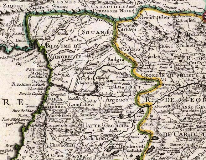
| Keywords: Lisle, Guillaume de.1723. Carte des Pays voisins de la Mer Caspiene, dressee pour l'usage du Roy (C).jpg fr Carte des Pays voisins de la Mer Caspiene dressee pour l'usage du Roy Sur la carte de cete Mer faite par l'ordre du Czar sur les Memoires manuscrits de Soskam-Sabbas Prince de Georgie sur ceux de Mrs Crusius Zurabek et Fabritius Ambassadeurs a la Cour de Perse et sur les eclaircissemens tirez d'un grand nombre de persones intelligentes du pais Assujetie aux observations astronomiques Par Guillaume Delisle Premier Geographe du Roy de l'Academie Royale des Sciences 15 Aout 1723 Marin sculpsit A Paris chez le Sr Delisle Quay de l'Horloge Image Lisle Guillaume de 1723 Carte des Pays voisins de la Mer Caspiene dressee pour l'usage du Roy jpg Original from http //www davidrumsey com/luna/servlet/detail/RUMSEY~8~1~2906~300042 www davidrumsey com Creator Guillaume Delisle 1723 PD-old-100 ImageNote 1 543 414 152 28 1019 793 2 D'Imiret ImageNoteEnd 1 ImageNote 2 513 477 126 29 1019 793 2 Argoueti ImageNoteEnd 2 ImageNote 3 220 477 95 29 1019 793 2 Guria ImageNoteEnd 3 ImageNote 4 393 140 176 40 1019 793 2 Souanes ImageNoteEnd 4 ImageNote 5 520 279 102 29 1019 793 2 Radgia ImageNoteEnd 5 ImageNote 6 122 512 65 24 1019 793 2 Gounia ImageNoteEnd 6 ImageNote 7 876 213 91 24 1019 793 2 Tianeti ImageNoteEnd 7 ImageNote 8 832 392 58 20 1019 793 2 Gory ImageNoteEnd 8 ImageNote 9 707 262 97 30 1019 793 2 Doualeti Davleti ßāōßāĢßāÉßāÜßāößāŚßāś ImageNoteEnd 9 ImageNote 10 298 393 45 23 1019 793 2 Poti ImageNoteEnd 10 ImageNote 11 592 715 126 24 1019 793 2 Dgakaveti ImageNoteEnd 11 ImageNote 12 615 736 103 23 1019 793 2 Akalkalaki ImageNoteEnd 12 ImageNote 13 510 540 98 23 1019 793 2 Akalzikaot ImageNoteEnd 13 ImageNote 14 221 205 185 95 1019 793 2 Royaume de<br/>Mingrelie ImageNoteEnd 14 ImageNote 15 177 315 49 20 1019 793 2 Ilori ImageNoteEnd 15 ImageNote 16 240 1 140 20 1019 793 2 Alanes ImageNoteEnd 16 ImageNote 17 443 20 224 52 1019 793 2 Caraciole sou<br/>Circasses Noirs ImageNoteEnd 17 ImageNote 18 930 151 83 32 1019 793 2 Pehavi ImageNoteEnd 18 ImageNote 19 87 451 136 25 1019 793 2 Pert de Copolet ImageNoteEnd 19 ImageNote 20 163 201 32 41 1019 793 2 Sukhumi ImageNoteEnd 20 ImageNote 21 221 515 112 30 1019 793 2 Aichara ImageNoteEnd 21 ImageNote 22 687 71 156 32 1019 793 2 Grand O├¤eti ImageNoteEnd 22 ImageNote 23 594 110 94 50 1019 793 2 Province d'O├¤eti ImageNoteEnd 23 ImageNote 24 876 62 111 54 1019 793 2 Province de Toucheti ImageNoteEnd 24 ImageNote 25 795 213 64 30 1019 793 2 Kevi ImageNoteEnd 25 ImageNote 26 253 454 78 24 1019 793 2 Oroufkeli ImageNoteEnd 26 ImageNote 27 240 702 136 34 1019 793 2 Chavcheti ImageNoteEnd 27 ImageNote 28 392 553 91 30 1019 793 2 Samfkae Samtskhe - ßāĪßāÉßāøßā¬ßā«ßāö ImageNoteEnd 28 ImageNote 29 386 400 74 25 1019 793 2 Coutatis Kutaisi ImageNoteEnd 29 ImageNote 30 455 225 89 68 1019 793 2 Lechgoumi ImageNoteEnd 30 ImageNote 31 56 274 98 36 1019 793 2 Port de Sahomi ImageNoteEnd 31 ImageNote 32 4 249 115 45 1019 793 2 Port de Poutchinda ImageNoteEnd 32 ImageNote 33 73 187 71 26 1019 793 2 Dandar Dranda - ßāōßāĀßāÉßā ßāōßāÉ ImageNoteEnd 33 ImageNote 34 9 12 114 30 1019 793 2 Ziques ImageNoteEnd 34 Guillaume Delisle Maps of Transcaucasia Old maps of the Russian Empire Old maps of Imereti 18th-century maps of Georgia Old maps of Samegrelo History of Svaneti History of Guria Maps of Circassia Maps of Alania Maps of the history of Abkhazia 1723 maps David Rumsey Historical Map Collection | ||||