MAKE A MEME
View Large Image

| View Original: | Italian empire 1914.png (1425x625) | |||
| Download: | Original | Medium | Small | Thumb |
| Courtesy of: | commons.wikimedia.org | More Like This | ||
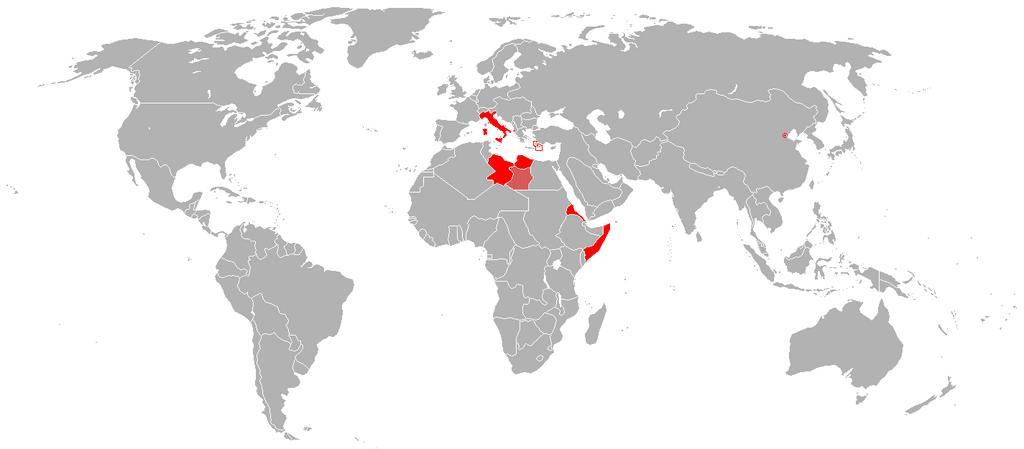
| Keywords: Italian empire 1914.png Map of the Italian Empire in 1914 Of note at this time the Vatican was not independent from Italy this occurred in 1929 The future colony of Libya is correctly shown in 1914 as the two separate Italian colonies it was at the time Tripolitania and Fezzan Cyrenaica is shown as a disputed area as both the United Kingdom and Italy laid claim to it Minuscule Italian possessions are surrounded by red circling including the small Italian holding of 46 hectares in Tianjin a Chinese trading city which had numerous European territorial holdings Hartă a Imperiului Italian în 1914 Vaticanul nu a fost stat independent până în 1929 Viitoarea colonie Libia este înfățiÈ™ată aÈ™a cum era în 1914 “ două colonii separate Tripolitania È™i Cirenaica Fezza este regiunea disputată de Italia È™i Regatul Unit Posesiunile mai mici sunt încercuite cu roÈ™u “ insulele Dodecaneze È™i cele 46 ha din Tianjin own enwiki 2007-10-31 R-41 R-41 Original upload log page en wikipedia Italian_empire_1914 png 2010-09-07 12 37 -kayac71- 1425×625× 29050 bytes <nowiki>error in te map west Jubaland Somalia was not Italian until 1924</nowiki> 2010-04-21 17 36 TheDJ 1425×625× 54081 bytes <nowiki>convert bmp to png</nowiki> 2007-10-31 19 48 R-41 1425×625× 2672554 bytes <nowiki>Map of the Italian colonial empire in 1914 Made by User R-41</nowiki> Maps showing the history of Italian colonies | ||||