MAKE A MEME
View Large Image

| View Original: | Israel Railways map 2013.svg (616x944) | |||
| Download: | Original | Medium | Small | Thumb |
| Courtesy of: | commons.wikimedia.org | More Like This | ||
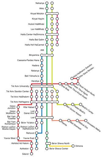
| Keywords: Israel Railways map 2013.svg Israel Railways map as at August 2013 Ir2011map2 png 50 2013-08-20 12 43 UTC Ir2011map2 png User Atefrat derivative work Begoon derivative work 100px Israel Railways map 2015 svg ambox Note that the type for station names is created as paths but plain type details and text are contained in a hidden svg layer to assist future editing Font is Helvetica Regular 13pt Rotation for angled names is +/- 35 degrees RetouchedPicture <p>Redrawn as vector and updated per this request at en WP Map workshop <br />https //en wikipedia org/w/index php title Wikipedia Graphics_Lab/Map_workshop oldid 569418831 Updates_to_File Ir2011map2 png https //en wikipedia org/w/index php title Wikipedia Graphics_Lab/Map_workshop oldid 569418831 Updates_to_File Ir2011map2 png permalink <br /> Begoon Ir2011map2 png Cc-zero Original upload log This image is a derivative work of the following images File Ir2011map2 png licensed with Cc-zero 2012-07-16T10 27 52Z Atefrat 2881x4328 512622 Bytes <nowiki>recommended transfer points based on official map</nowiki> 2012-07-11T06 56 44Z Atefrat 2453x4280 486716 Bytes <nowiki>stations on green line according to official sources</nowiki> 2012-05-23T14 03 35Z Atefrat 2453x4280 486378 Bytes <nowiki>adjust placement</nowiki> 2012-05-23T13 49 25Z Atefrat 2453x4280 485039 Bytes <nowiki>Yavne West station added</nowiki> 2012-05-23T13 45 58Z Atefrat 2453x4280 485039 Bytes <nowiki>Yavne West Station added</nowiki> 2011-10-19T09 04 15Z Atefrat 2453x4280 480768 Bytes <nowiki></nowiki> Uploaded with derivativeFX Israel Railways maps | ||||