MAKE A MEME
View Large Image

| View Original: | Hurricane_Dennis,_Image_of_the_Day_DVIDS845575.jpg (5600x7200) | |||
| Download: | Original | Medium | Small | Thumb |
| Courtesy of: | commons.wikimedia.org | More Like This | ||
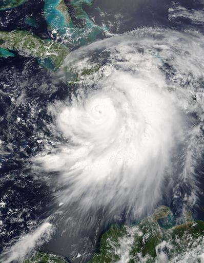
| Keywords: Hurricane Dennis, Image of the Day DVIDS845575.jpg en Hurricane Dennis threaded its way between Jamaica and Haiti on a direct course for Cuba on July 7 2005 The storm now has the distinctive hurricane form with a well-defined eye surrounded by bands of swirling clouds At 10 50 a m local time 15 50 UTC when the Moderate Resolution Imaging Spectroradiometer modis gsfc nasa gov MODIS on NASA's terra nasa gov/ Terra satellite took this image Dennis was just below a Category 3 hurricane with winds of 175 kilometers per hour 110 miles per hour and stronger gusts Less than an hour before this image was taken the storm's small dark eye was about 105 kilometers 65 miles northeast of Kingston Jamaica and 170 kilometers 105 miles south-southeast of Guantanamo Cuba The National Hurricane Center reports that Dennis is traveling northwest at about 24 kilometers per hour 15 mph A storm of this size is a threat not just because of its powerful winds Dennis is expected to produce heavy rain and coastal and inland flooding Five to ten inches of rain may fall over Haiti the Dominican Republic Jamaica Cuba and the Cayman Islands with as much as 15 inches falling in parts of Jamaica Heavy rainfall can trigger flash floods and mudslides in mountainous regions The storm will probably also raise tide levels by five to seven feet and generate large and dangerous waves Dennis is expected to strengthen as it moves north towards the Gulf Coast of the United States For official storm warnings and additional information please visit the www nhc noaa gov/ National Hurricane Center The image is available in rapidfire sci gsfc nasa gov/gallery/ 2005188-0707/Dennis A2005188 1550 2km jpg additional resolutions from the MODIS Rapid Response Team NASA Identifier Dennis_TMO_2005188 2011-07-05 Glenn Research Center https //www dvidshub net/image/845575 845575 2013-02-08 11 09 WASHINGTON D C US PD-USGov Hurricane Dennis Images from DoD uploaded by Fæ | ||||