MAKE A MEME
View Large Image

| View Original: | Halifax Explosion blast cloud restored.jpg (1200x1905) | |||
| Download: | Original | Medium | Small | Thumb |
| Courtesy of: | commons.wikimedia.org | More Like This | ||
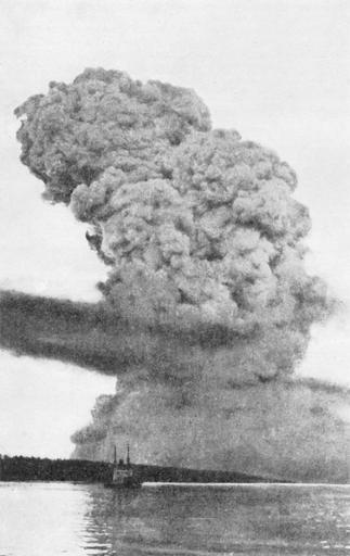
| Keywords: Halifax Explosion blast cloud restored.jpg estimates the distance from the explosion as 21 km/13 mi the actual location and distance have never been firmly established <br><br> However the height of the blast at its peak was measured at 3 600 metres 11 811 feet or 2 25 miles on a sextant by Captain W M A Campbell of the Canadian merchant ship Acadian approximately 28 km 18 mi from the harbour approaches This measurement is consistent with the time-frame of 15-20 seconds at a distance of 1 mile <br><br> Furthermore documented photographic evidence from the Ron Fralick Collection photo reference numbers 16 274 16 275 - Maritime Museum of the Atlantic clearly shows the size shape and direction of the blast cloud as it passed by York Redoubt and indicates that the original photograph was probably taken from Bedford Basin <br><br> In Canada - from the David Millar Collection NLAC In the U S - National Archives and Records Administration NARA Reference 165-WW-158A-15 Original source Underwood Underwood Print only - no negative available <br><br> Reproduction service has been withdrawn in Canada NLAC In the U S reproductions are available from NARA PA-166585 3531262 1917-12-06 author PD-Canada PD-1923 Photo guy4god 2007-03 Photo guy4god thumb left Unrestored version original upload log page en wikipedia Halifax_Explosion_blast_cloud_restored jpg 2009-01-20 03 45 Mike lifeguard 1200Ă—1905Ă— 635850 bytes <nowiki>hopefully smoother</nowiki> 2007-03-22 14 00 Photo guy4god 1200Ă—1905Ă— 477106 bytes <nowiki> View from the Northwest Arm -- a distance of 2 1 kilometres of the column of smoke raised by the Halifax Explosion May be the only photograph of the blast itself 6 Dec 1917 / Halifax N S vicinity ” 1 item ” 125 x 100 mm Source Library and Archives Canada USE/ </nowiki> An original unrestored version is available here info Halifax Explosion Bedford Basin | ||||