MAKE A MEME
View Large Image

| View Original: | GreatBritain802.png (323x480) | |||
| Download: | Original | Medium | Small | Thumb |
| Courtesy of: | commons.wikimedia.org | More Like This | ||
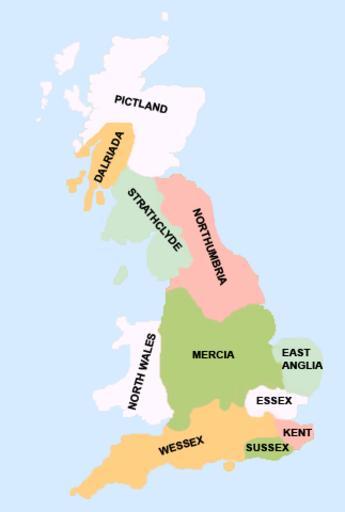
| Keywords: GreatBritain802.png This is an image of the 802 kingdoms of what is now known as Great Britain England Scotland and Wales I created this image Created under this guidence of this of historical source of a http //images nationmaster com/images/motw/historical/shepherd/british_isles_802 jpg 802 map of Britain which itself was developed by cartographer and historian William R Shepherd en wikipedia 2007-12-23 Yorkshirian wikipedia en Yorkshirian ma 02 original upload log page en wikipedia GreatBritain802 png 2007-12-23 05 39 Yorkshirian 323×480× 31542 bytes <nowiki>This is an image of the 802 kingdoms of what is now known as Great Britain England Scotland and Wales I created this image Yorkshirian </nowiki> Maps of the history of the United Kingdom Maps of Anglo-Saxon England Maps showing 9th-century history | ||||