MAKE A MEME
View Large Image

| View Original: | Global tropical cyclone tracks-edit2.jpg (8000x4000) | |||
| Download: | Original | Medium | Small | Thumb |
| Courtesy of: | commons.wikimedia.org | More Like This | ||
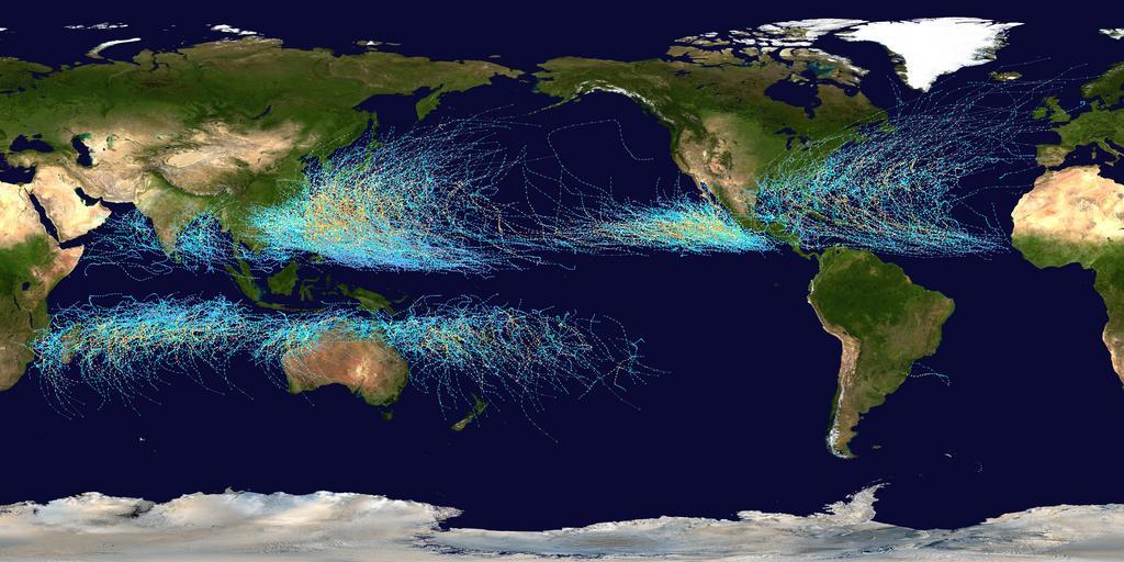
| Keywords: Global tropical cyclone tracks-edit2.jpg Assessments 5 2006 1 1 1 1 1 1 çåẁḊæḞæååẁåẅ top border 0 cellspacing 0 cellpadding 0 style background transparent;text-align center - 7 nowrap nowrap <small>Saffir-Simpson Hurricane Scale</small> - background-color 5ebaff;width 1 8em title Tropical Depression 0 38 mph 0 62 km/h TD background-color 00faf4;width 1 8em title Tropical Storm 39 73 mph 63 117 km/h TS background-color ffffcc;width 1 8em title Category 1 74 95 mph 119 153 km/h 1 background-color ffe775;width 1 8em title Category 2 96 110 mph 154 177 km/h 2 background-color ffc140;width 1 8em title Category 3 111 130 mph 178 209 km/h 3 background-color ff8f20;width 1 8em title Category 4 131 155 mph 210 249 km/h 4 background-color ff6060;width 1 8em title Category 5 > 156 mph > 250 km/h 5 SvÄtové tropické cyklony v letech 1985 - 2005 This map shows the tracks of all Tropical cyclones which formed worldwide from 1985 to 2005 The points show the locations of the storms at six-hourly intervals and use the color scheme shown to the right from the Saffir-Simpson Hurricane Scale Este mapa muestra los recorridos de todos los ciclones tropicales que se formaron desde 1985 hasta 2005 Los puntos muestran las localizaciones de las tormentas en intervalos de seis horas y utilizan el esquema de color a la derecha de la Escala de huracanes de Saffir-Simpson Diese Karte zeigt die Verlaufsbahnen der Tropischen WirbelstÃỳrme von 1985 bis 2005 Die farbigen Punkte zeigen die Positionen der StÃỳrme in sechs-stÃỳndlichen AbstÃĊnden und verdeutlichen die IntensitÃĊt eines Sturmes zu diesen Zeitpunkten auf der Saffir-Simpson-Hurrikan-Skala Cette carte montre les traces de tous les cyclones tropicaux qui se sont formés entre 1985 et 2005 Les points montrent l'emplacement des cyclones à des intervalles de six heures et leur couleur indique leur intensité sur l'échelle de Saffir-Simpson Esse mapa mostra as rotas de todos os ciclones tropicais que se formaram entre 1985 e 2005 Os pontos indicam suas localizaçÃṁes registradas a cada seis horas O esquema de cores ao lado é baseado na escala Saffir-Simpson Ang mapang ito ay nagpapakita ng dinaanan ng mga bagyo sa buong mundo mula 1985 hanggang 2005 Ang mga tuldok ay nagpapakita ng galaw ng bagyo kada anim na oras Makikita rin ang ibat-iang kulay ng bawat linya na magbibigay impormasyon sa lakas o hina ng isang isang bagyo sa pamamagitan Saffir-Simpson Hurricane Scale Bu harita 1985 ile 2005 yÄḟlarÄḟ arasÄḟnda dÃỳnyada meydana gelen tÃỳm tropik kasÄḟrgalarÄḟn hareketlerini göstermektedir Her bir nokta altÄḟ saatlik aralarla kasÄḟrganÄḟn yerini kullanÄḟlan renkler ise kasÄḟrgalarÄḟn Saffir-Simpson ölçeÄine göre Åiddetlerini gösterir Ŵ ŴḞ ÑÑŴẅŴṗ ŴẃŴḞÑ ÑŴṁ ŴṡŴẅŴẃŴḞŴṖŴḞŴẄÑ ŴṡÑÑŴẁ ŴĠÑŴṁÑ ÑÑ ŴẅŴṡŴẁÑŴṁÑŴẃŴẁÑ ÑŴẁŴẃŴṠŴẅŴẄŴẅŴĠ ŴṖŴḞ 1985-2005 ŴġŴġ Ŵ ŴḞ ŴẃŴḞŴ¶ŴṀŴẅŴỳ ŴṡÑÑŴẁ ÑŴẅÑŴẃŴẁ ÑŴẅŴẅÑŴĠŴṁÑÑÑŴĠÑÑÑ ŴṡŴẅŴṠŴẅŴ¶ŴṁŴẄŴẁÑŴỳ ÑŴẁŴẃŴṠŴẅŴẄŴḞ ÑŴṁÑ ŴṁŴṖ ŴẃŴḞŴ¶ŴṀÑŴṁ 6 ÑŴḞÑŴẅŴĠ; ŴẁÑ ÑŴĠŴṁÑ ÑŴẃŴḞŴṖÑŴĠŴḞŴṁÑ ÑŴẁŴṠÑ ÑŴẁŴẃŴṠŴẅŴẄŴḞ ŴṡŴẅ ÑŴẃŴḞŴṠŴṁ ŴḂŴḞÑÑŴẁÑ ŴḞ-ŴḂŴẁŴỳŴṡÑŴẅŴẄŴḞ TÃḂto mapa ukazuje trasy vÅḂetkÃẄch tropickÃẄch cyklÃġnov ktoré sa vytvorili po celom svete v rokoch 1985 aÅẅ 2005 Body ukazujÃẃ umiestenie bÃẃrky v ÅḂesÅċhodinovÃẄch intervaloch a pouÅẅÃvajÃẃ farebnÃẃ ÅḂkÃḂlu zobrazenÃẃ vpravo podÄẅa Saffirovej-Simpsonej hurikÃḂnovej stupnice æĊå Ḟå åḟçĊẃèẂ1985åṗṀèġ2005åṗṀéäẁçåå Ḟçḟåẁ¶æḞ£æåäẄåèṖŸåẅã èṖŸåẅäṠċæŸ6åḞæçẃäẁ éṠïỳäẁḊæè©èĠçẅ-èẅæ®æ£®éḃ¶éḃẀççṀïỳSaffir-Simpson Hurricane ScaleïỳåçẃäẁåéḂèĠã Created using User jdorje/Tracks by Nilfanion on 2006-08-05 Background image from File Whole_world_-_land_and_oceans jpg NASA Tracking data for storms within the Atlantic and Eastern Pacific basins is taken from the National Hurricane Center and the Central Pacific Hurricane Center 's http //www nhc noaa gov/data/hurdat/hurdat2-nencpac-1949-2012-040513 txt Northeast and North Central Pacific hurricane database The tracking data for storms within the Indian Ocean the Northwest Pacific and the Southern Pacific is from the Joint Typhoon Warning Center Tracking data for Cyclone Catarina in the South Atlantic was published in http //www australiasevereweather com/cyclones/2004/trak0403 htm Gary Padgett's April 2004 Monthly Tropical Cyclone Summary and was originally produced by Roger Edson of the University of Guam 2006-08-05 Background image NASA this version Nilfanion Used within Mogil H Michael Extreme Weather Understanding the Science of Hurricanes Tornadoes Floods Heat Waves Snow Storms Global Warming and Other Atmospheric Disturbances pp 61 Hardcover - Nov 13 2007 Awards Picture of the day 01 06 2007 Cumulative tropical cyclone tracks Maps of hurricanes and typhoons Maps of weather and climate in the 20th century 1985-2005 Maps of weather and climate in the 2000s 1985-2005 Mean meteorological data of the world | ||||