MAKE A MEME
View Large Image

| View Original: | Europe map Napoleon 1811.svg (415x422) | |||
| Download: | Original | Medium | Small | Thumb |
| Courtesy of: | commons.wikimedia.org | More Like This | ||
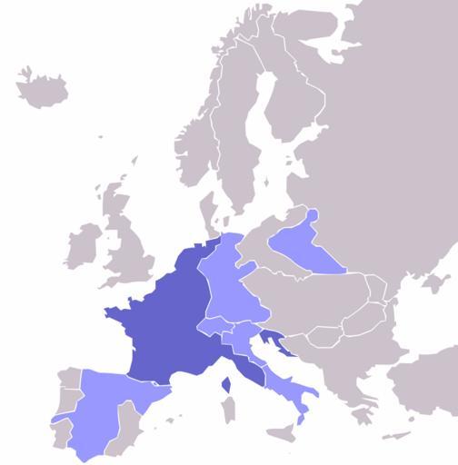
| Keywords: Europe map Napoleon 1811.svg Inaccurate-map-disputed The overly-straight West coast of Ireland is clearly a glitch This is Ireland File Ireland_ MODIS jpg Inaccurate-map-disputed The Duchy of Warsaw must be re-drawn to an accurate shape according to File Duchy of Warsaw and Republic of Danzig JPG Map of the w First French Empire and satellite states with w 1811 borders Created by User OwenBlacker from Image Europe blank map png therefore they are the source Europe_map_Napoleon_1811 png 2009-05-03 00 13 UTC Europe_map_Napoleon_1811 png OwenBlacker derivative work Mnmazur <span class signature-talk >talk</span> File Europe map Napoleon 1811 png cc-by-sa-2 0-uk </nowiki> Uploaded with derivativeFX ImageNote 1 90 238 123 112 415 422 2 Main French Empire ImageNoteEnd 1 ImageNote 2 60 330 93 84 415 422 2 Kingdom of Spain areas taken over by French Empire ImageNoteEnd 2 ImageNote 6 182 205 56 82 415 422 2 Confederation of the Rhine French Vassal ImageNoteEnd 6 ImageNote 7 255 199 51 49 415 422 2 Duchy of Warsaw French Vassal Note the shape in this image is incorrect ImageNoteEnd 7 ImageNote 8 181 288 31 17 415 422 2 Swiss Confederation French Vassal ImageNoteEnd 8 ImageNote 9 213 293 25 34 415 422 2 Kingdom of Italy French Vassal ImageNoteEnd 9 ImageNote 10 242 332 44 50 415 422 2 Kingdom of Naples French Ally ImageNoteEnd 10 ImageNote 11 237 296 33 31 415 422 2 Venice region Part of French Empire ImageNoteEnd 11 1811 in Europe Maps of the First French Empire 1811 Maps of the Napoleonic Wars | ||||