MAKE A MEME
View Large Image

| View Original: | ElectoralCollege1832.svg (559x557) | |||
| Download: | Original | Medium | Small | Thumb |
| Courtesy of: | commons.wikimedia.org | More Like This | ||
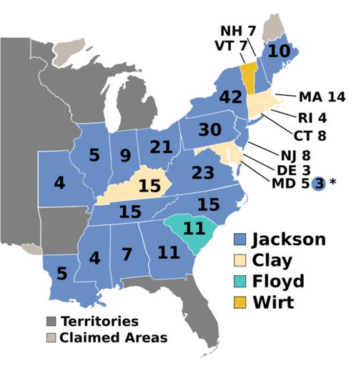
| Keywords: ElectoralCollege1832.svg US presidential election maps SVG Electoral college map for the 1832 United States presidential election This image was adapted from File ElectoralCollege1828 svg itself adapted from File Map of territorial growth 1775 svg and File ElectoralCollege1964 svg both based off File Blank_US_Map svg using data from http //www archives gov/federal-register/electoral-college/votes/1821_1837 html 1832 Electoral College Box Scores 1789 “1996 <i>http //www archives gov/ Official website of the National Archives</i> February 23 2011 http //www davidrumsey com/luna/servlet/detail/RUMSEY~8~1~200385~3000327 United-States-Of-America--by-H-S--T qvq q Publication_Author 3D 22Tanner 2C 2BHenry 2BS 22 2BAND 2BPub_Type 3D 22Case 2BMap 22 2BAND 2BPub_Title 3D 22united 2Bstates 22 2B;sort Pub_Date 2CPub_List_No_InitialSort 2CPub_List_No 2CSeries_No;lc RUMSEY~8~1 mi 4 trs 9 embedded true sort Pub_Date 2CPub_List_No_InitialSort 2CPub_List_No 2CSeries_No cic RUMSEY 7E8 7E1 widgetFormat javascript widgetType detail controls 1 nsip 1 United States Of America by H S Tanner 1832 Third Edition File United_States_1828-1834 png the original version uploaded by AndyHogan14 and the National Atlas of the United States Cg-realms current <br />AndyHogan14 original 2008-12-31 Original ; 2011-02-23 Current File ElectoralCollege1832-Large png 1832 U S presidential election maps | ||||