MAKE A MEME
View Large Image

| View Original: | Dep-fr.jpg (2091x1513) | |||
| Download: | Original | Medium | Small | Thumb |
| Courtesy of: | commons.wikimedia.org | More Like This | ||
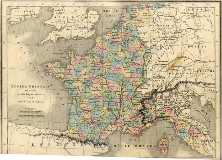
| Keywords: Dep-fr.jpg en French departements under the first empire in 1811 precisely Note The Liamone department was merged with the Golo department on April 19th 1811 ; the Lippe department was created on April 26th 1811 ; therefore Liamone and Lippe departments never existed officially both at the same time although they are both drawn on the map fr Les dÊpartements français sous le premier empire en 1811 prÊcisÊment Note Le dÊpartement du Liamone fut fusionnÊ avec celui du Golo le 19 avril 1811 ; le dÊpartement de la Lippe fut crÊÊ le 26 avril 1811 ; les dÊpartements numÊros du Liamone et de la Lippe n'ont donc jamais existÊ officiellement en même temps bien qu'ils soient tous deux reprÊsentÊs sur la carte it I dipartimenti francesi sotto il primo impero precisamente nel 1811 Nota Il dipartimento di Liamone venne unito con quello di Golo il 19 aprile 1811 ; Il dipartimento del Lippe venne creato il 26 aprile 1811 ; dunque i dipartimenti di Liamone e del Lippe ufficialmente non esistettero mai allo stesso tempo sebbene siano stati entrambi rappresentati sulla mappa Image file made from old map from MM Drioux and Leroy shown at http //www es-conseil fr/pramona/outils/cartes htm Les DÊpartements français sous l'Empire Another version of this map in higher resolution can be found there carte de l http //cartotecadigital icc cat/cdm/singleitem/collection/europa/id/1682/rec/5 Empire français divisÊ en 130 dÊpartements par MM Drioux et Leroy MM Drioux et Leroy 1866 paper version PD-old 1811 in France 1866 maps Old maps of the First French Empire Old maps of Belgium Old maps of France Old maps of Italy Old maps of the Netherlands 1866 | ||||