MAKE A MEME
View Large Image

| View Original: | Atlas_Van_der_Hagen-KW1049B10_040-Delineatio_Generalis_CAMPORUM_DESERTORUM_vulgo_UKRAINA,_Cum_adjacentibus_Provinciis_Bono_publico_erecta.jpeg (5500x4277) | |||
| Download: | Original | Medium | Small | Thumb |
| Courtesy of: | commons.wikimedia.org | More Like This | ||
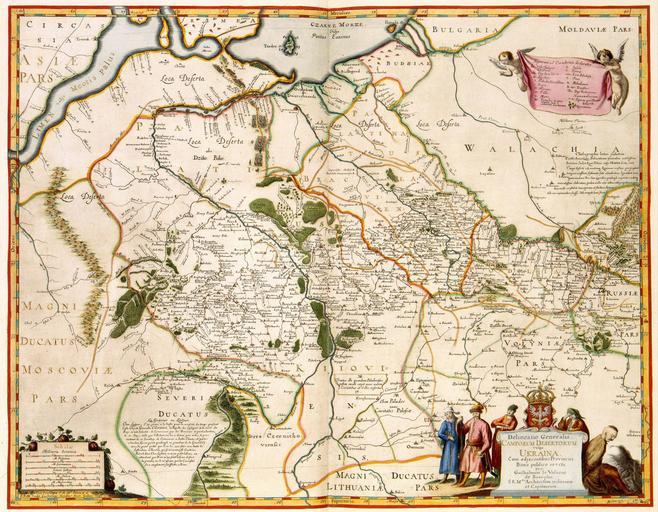
| Keywords: Atlas Van der Hagen-KW1049B10 040-Delineatio Generalis CAMPORUM DESERTORUM vulgo UKRAINA, Cum adjacentibus Provinciis Bono publico erecta.jpeg of the Atlas Van der Hagen in the catalogue of the KB http //opc4 kb nl/DB 1/TTL 1/LNG EN/PPN PPN 353012750 Creator Guillaume_le_Vasseur_de_Beauplan Author per Guilhelmum le Vasseur de Beauplan S R M tis Architectum militarem et Capitaneum S R M tis Sculpt Guilhelmus Hondius fecit Gedani 1648 Publisher Willem Hondius Author per Guilhelmum le Vasseur de Beauplan S R M tis Architectum militarem et Capitaneum S R M tis Sculpt Guilhelmus Hondius fecit Gedani 1648 Publisher Willem Hondius credit line 1648 De Oekraïne was in de 17de eeuw verdeeld tussen Polen en Rusland Om dit enorme grondgebied te kunnen beheersen en tegen vijanden te beschermen liet de Poolse koning Władysław IV Vasa het gebied in kaart brengen door de Franse militair Guillaume Le Vasseur de Beauplan 1595-1685 Deze overzichtskaart van de Oekraïne werd in 1639 door de Beauplan samengesteld door Willem Hondius ca 1597-voor 1660 gegraveerd en in 1648 door dezelfde Hondius in Gdansk uitgegeven The Ukraine was divided between Poland and Russia in the 17th century In order to control this enormous area and to protect it against enemies the Polish king Władysław IV Vasa ordered the complete territory to be surveyed and mapped by the French military Guillaume Le Vasseur de Beauplan 1595-1685 This survey plan of the Ukraine was composed in 1639 by De Beauplan engraved and published by Willem Hondius in 1648 in Gdansk 42 5 x 54 cm exhibition history Institution Koninklijke Bibliotheek kopergravure Technique copper engraving KW1049B10_040 - Volume 1 Guillaume Le Vasseur de Beauplan - Hondius Willem - Władysław IV Vasa van Polen Information field Depicted locations Russia - Ukraine object history object type Kaart Map PD-old-100 place of creation Gdansk place of discovery Source page at the http //resolver kb nl/resolve urn urn gvn KONB01 40 Geheugen van Nederland / Memory of the Netherlands website Koninklijke Bibliotheek Delineatio Generalis CAMPORUM DESERTORUM vulgo UKRAINA Cum adjacentibus Provinciis Bono publico erecta Uploaded with GWToolset Atlas Van der Hagen-KW1049B10_040-Delineatio Generalis CAMPORUM DESERTORUM vulgo UKRAINA Cum adjacentibus Provinciis Bono publico erecta http //resolver kb nl/resolve urn urn gvn KONB01 1049B10_040 size large Atlas van der Hagen | ||||