MAKE A MEME
View Large Image

| View Original: | 59_Athelstan_/_Athelstan,_59_...._now_identified_as_59_Maxse_Road,_Knowle_in_Bristol,_c.1906.jpg (1000x652) | |||
| Download: | Original | Medium | Small | Thumb |
| Courtesy of: | www.flickr.com | More Like This | ||
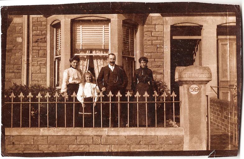
| Keywords: athelstan mystery unidentified whatsthatpicture bristol 59 maxse road 59maxseroad maxse road maxseroad knowle astle joseph astle josephastle findery public domain publicdomain Thanks to the sleuthing of a number of Flickr users (see comments below) not only has the exact location of this house been identified from just a few tiny clues, but we are also pretty certain when it was taken and who they are. For posterity, here's the original description showing some of the evidence and speculation as to the location ... The number on the post is clearly 59, and the stone capping says "Athelstan". Athelstan Road? Avenue? But where? But it is equally possible that the house might be named Athelstan (after an English king) and the road is something entirely different. The architecture suggests a suburban locations. The stone walls rather than brick would also narrow it down a bit. Google maps gives quite a few possibilities (maps.google.co.uk/maps?f=q&source=s_q&hl=en&g...): Athelstan Rd, Southampton, Hampshire SO19, UK Athelstan Rd, Hastings, East Sussex TN35, UK Athelstan Rd, Faversham, Kent ME13, UK Athelstan Rd, Dorchester, Dorset DT1, UK Athelstan Rd, Exeter, Devon EX1, UK Athelstan Rd, Sheffield, South Yorkshire S13, UK Athelstan Rd, Romford, Essex RM3, UK Athelstan Rd, Kettering, Northamptonshire NN16, UK Athelstan Rd, Whitchurch, Cardiff, South Glamorgan CF14, UK Athelstan Rd, Margate, Kent CT9, UK As for date, my instinct says c. 1900-1910. Albumen print from glass negative. c. 5.5 x 3.5" Thanks to the sleuthing of a number of Flickr users (see comments below) not only has the exact location of this house been identified from just a few tiny clues, but we are also pretty certain when it was taken and who they are. For posterity, here's the original description showing some of the evidence and speculation as to the location ... The number on the post is clearly 59, and the stone capping says "Athelstan". Athelstan Road? Avenue? But where? But it is equally possible that the house might be named Athelstan (after an English king) and the road is something entirely different. The architecture suggests a suburban locations. The stone walls rather than brick would also narrow it down a bit. Google maps gives quite a few possibilities (maps.google.co.uk/maps?f=q&source=s_q&hl=en&g...): Athelstan Rd, Southampton, Hampshire SO19, UK Athelstan Rd, Hastings, East Sussex TN35, UK Athelstan Rd, Faversham, Kent ME13, UK Athelstan Rd, Dorchester, Dorset DT1, UK Athelstan Rd, Exeter, Devon EX1, UK Athelstan Rd, Sheffield, South Yorkshire S13, UK Athelstan Rd, Romford, Essex RM3, UK Athelstan Rd, Kettering, Northamptonshire NN16, UK Athelstan Rd, Whitchurch, Cardiff, South Glamorgan CF14, UK Athelstan Rd, Margate, Kent CT9, UK As for date, my instinct says c. 1900-1910. Albumen print from glass negative. c. 5.5 x 3.5" | ||||