MAKE A MEME
View Large Image

| View Original: | 2011 Battle of Sirte.svg (820x596) | |||
| Download: | Original | Medium | Small | Thumb |
| Courtesy of: | commons.wikimedia.org | More Like This | ||
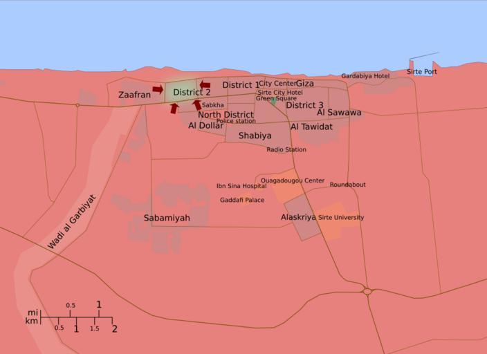
| Keywords: 2011 Battle of Sirte.svg en A map of the 2011 Battle of Sirte showing troop movements In green Gaddafi Loyalists in red Libyan Rebels Sources Google Maps and Wikimapia for the geography of the city Reuters Al Jazeera etc for troop movements 2011-10-08 own Ave César Filito Template Other versions/Libyan Uprising Cc-zero ImageNote 1 612 223 44 36 1165 674 2 This area is under NTC troops` controll as a highway between City center Wagadugu complex was cut by NTC forces on October 8 according to numerous sources ex http //www france24 com/en/20111008-libya-fighters-seize-strategic-highway-sirte ImageNoteEnd 1 ImageNote 2 390 160 25 20 1165 674 2 There is very little information about this front and it is not known where the frontilne exactly is ImageNoteEnd 2 ImageNote 4 456 164 19 25 821 597 2 only part still in loyalist control http //af reuters com/article/libyaNews/idAFL5E7LD01M20111013 ImageNoteEnd 5 ImageNote 5 271 113 106 70 821 597 2 only part still in loyalist control http //af reuters com/article/libyaNews/idAFL5E7LD01M20111013 ImageNoteEnd 5 ImageNote 5 271 113 106 70 821 597 2 Gaddafi is dead and Sirte is now liberated ImageNoteEnd 5 Maps of the 2011 Libyan civil war Sirte Sirte Battle 2011 SVG maps in English Sirte In 2011 Libyan Civil War Uploaded with UploadWizard | ||||