MAKE A MEME
View Large Image

| View Original: | 1893_U.S._Coast_Survey_Nautical_Chart_or_Map_of_the_Chesapeake_Bay_and_Delaware_Bay_-_Geographicus_-_ChesapeakeBay-uscs-1893.jpg (5000x6672) | |||
| Download: | Original | Medium | Small | Thumb |
| Courtesy of: | commons.wikimedia.org | More Like This | ||
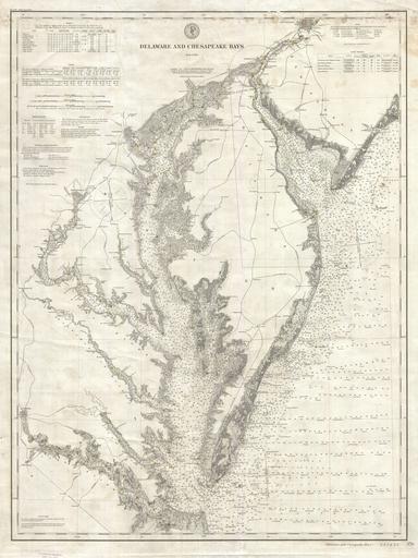
| Keywords: 1893 U.S. Coast Survey Nautical Chart or Map of the Chesapeake Bay and Delaware Bay - Geographicus - ChesapeakeBay-uscs-1893.jpg This is a rare example of the 1893 U S Coast Survey Map or Nautical Chart of the Chesapeake Bay and Delaware Bay This chart is based on survey work initiated in 1855 and has been updated to 1893 Covers from Philadelphia south as Cape Henry and Norfolk Includes both the Chesapeake Bay and Delaware Bay in full as well as significant portions of the Potomac River Rappahannock River York River James River Patapsco River and Patuxent River Includes the major centers of Philadelphia Washington D C Wilmington Baltimore and Richmond Offers stupendous detail both inland and at sea Notes all major railroads communities and shoreline features Nautically this map really shines There are thousands of depth soundings shading for undersea shoals and other dangers and red and yellow color coding for buoys light ships and lighthouses This chart is not to be confused with the similar folded charts that are commonly issued in the Annual Report of the Superintendent of the Coast Survey Rather it is an independently issued chart on heavy stock It has never been folded Most likely this chart has actually been used to sail Such charts are much less common and far more desirable than the folded Report charts This map was published by the United States Coast and Geodetic Survey as chart no 376 under the supervision of T C Mendenhall 1893 dated Size in 28 36 object history credit line accession number ChesapeakeBay-uscs-1893 Geographicus-source PD-USgov United States Coast Survey maps Old maps of the Chesapeake Bay Old maps of the Delaware Bay United States Coast Survey 1893 maps | ||||