MAKE A MEME
View Large Image

| View Original: | 1740_Homann_Map_of_the_Holy_Roman_Empire_(_Germanic_Empire_)_-_Geographicus_-_ImperiiRomanoGerman-homann-1740.jpg (5000x4353) | |||
| Download: | Original | Medium | Small | Thumb |
| Courtesy of: | commons.wikimedia.org | More Like This | ||
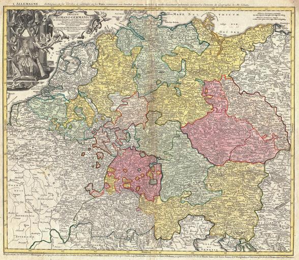
| Keywords: 1740 Homann Map of the Holy Roman Empire ( Germanic Empire ) - Geographicus - ImperiiRomanoGerman-homann-1740.jpg A beautifully detailed c 1740 J B Homann map of those parts of Europe dominated by the Holy Roman Empire or the German Empire Depicts most of central Europe from the Netherlands eastward as far as Poland and Hungary and as far south as northern Italy and the Gulf of Venice Elaborate title cartouche in the upper left quadrant features the Emperor surrounded by angels and heraldic symbols Map scales in upper right hand quadrant Key to color coding outside border on lower margin Alternative title in French in top margin L ™ Allemagne distinguee en ses Cercles subdivisee en ses Etats contenant los Elements de Geographiae de Mr Shatz This map was drawn in Nuremberg by J B Homann and included in the 1752 Homann Heirs Maior Atlas Scholasticus ex Triginta Sex Generalibus et Specialibus ¦ circa 1720 undated Size in 21 18 75 object history credit line accession number ImperiiRomanoGerman-homann-1740 <i>Major Atlas Scholasticus Ex Triginta sex Generalibus et Specialibus Mappis Homannianis </i> c 1730 / Also issued in Homann's <i>Grosser Atlas</i> Geographicus-source PD-old-100 Johann Baptist Homann Old maps of the Holy Roman Empire 1740 maps Maps in Latin | ||||